Perry - Perry Warsaw
Airport details
| Country | United States of America |
| State | New York |
| Region | K6 |
| Airspace | Cleveland Ctr |
| Municipality | Town of Perry |
| Elevation | 1559ft (475m) |
| Timezone | GMT -5 |
| Coordinates | 42.74136, -78.05214 |
| Magnetic var | |
| Type | land |
| Available since | X-Plane v10.40 |
| ICAO code | 01G |
| IATA code | n/a |
| FAA code | n/a |
Communication
| Perry Warsaw UNICOM | 122.800 |
Nearby Points of Interest:
Perry Downtown Historic District
-Silver Lake Institute Historic District
-Epworth Hall
-Monument Circle Historic District
-Warsaw Downtown Historic District
-Warsaw Academy
-United States Post Office
-Seth M. Gates House
-Middlebury Academy
-Bryant Fleming House
-Coverdale Cobblestone House
-Murray Street Historic District
-Letchworth State Park
-House at No. 48 Grove Street
-State and Eagle Streets Historic District
-House at No. 13 Grove Street
-St. John's Episcopal Church
-Gen. William A. Mills House
-House at No. 30 Murray Street
-New Family Theater
-House at No. 8 State Street
-South Main Street Historic District
-House at No. 176 South Main Street
-Linwood
-Westerly (Piffard, New York)
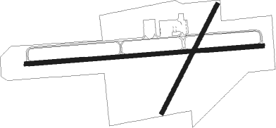
Runway info
Runway 10 / 28  | ||
| length | 1066m (3497ft) | |
| bearing | 90° / 270° | |
| width | 18m (60ft) | |
| surface | asphalt | |
| displ threshold | 0m (0ft) / 195m (640ft) | |
| Runway 04 / 22 | ||
| length | 543m (1781ft) | |
| bearing | 40° / 220° | |
| width | 18m (60ft) | |
| surface | grass | |
| displ threshold | 28m (92ft) / 0m (0ft) | |
Nearby beacons
| code | identifier | dist | bearing | frequency |
|---|---|---|---|---|
| GEE | GENESEO VOR/DME | 15.1 | 74° | 108.20 |
| ROC | ROCHESTER VOR/DME | 28.1 | 45° | 110 |
| BUF | BUFFALO VOR/DME | 28.4 | 288° | 116.40 |
| BU | KLUMP (BUFFALO) NDB | 30.5 | 293° | 231 |
| GB | PLAZZ (BUFFALO) NDB | 34.6 | 280° | 204 |
| ELZ | DME | 39.2 | 175° | 111.40 |
| IA | KATHI (NIAGRA FALLS) NDB | 41 | 295° | 329 |
| PYA | PENN YAN NDB | 44.3 | 96° | 260 |
| IAG | NIAGARA FALLS TACAN | 45.7 | 292° | 111 |
| BFD | DME | 62.6 | 211° | 116.60 |
Disclaimer
The information on this website is not for real aviation. Use this data with the X-Plane flight simulator only! Data taken with kind consent from X-Plane 12 source code and data files. Content is subject to change without notice.