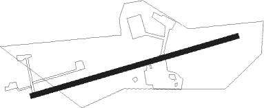
Clanton - Gragg Wade Field
Airport details
| Country | United States of America |
| State | Alabama |
| Region | K7 |
| Airspace | Atlanta Ctr |
| Municipality | Clanton |
| Elevation | 583ft (178m) |
| Timezone | GMT -6 |
| Coordinates | 32.85048, -86.61143 |
| Magnetic var | |
| Type | land |
| Available since | X-Plane v10.40 |
| ICAO code | 02A |
| IATA code | n/a |
| FAA code | n/a |
Communication
| Gragg Wade Field CTAF/UNICOM | 122.800 |
| Gragg Wade Field MONTGOMERY Approach/Departure | 121.200 |
Nearby Points of Interest:
Chilton County Airport
-Verbena
-Walker-Klinner Farm
-Pinhoti National Recreation Trail
-Mount Sinai School
-Montebrier
-McKibbon House Bed & Breakfast
-Driskell-Martin House
-Antique Store (Plantersville, Alabama)
-Old Shelby County Courthouse
-Downtown Montevallo Historic District
-Christian Church and Parsonage
-Edmund King House
-Todd House (Plantersville, Alabama)
-Brierfield Furnace
-B. B. Comer Memorial Library
-Montgomery-Janes-Whittaker House
-Davidson-Smitherman House
-Bibb County Courthouse
-Fort Toulouse
-First Presbyterian Church of Wetumpka
-First United Methodist Church
-Wetumpka State Penitentiary
-Riverdale (Selma, Alabama)
-Old Rock House
Nearby beacons
| code | identifier | dist | bearing | frequency |
|---|---|---|---|---|
| MXF | MAXWELL (MONTGOMERY) TACAN | 30.8 | 153° | 115 |
| MG | MARRA (MONTGOMERY) NDB | 32.7 | 169° | 245 |
| SE | POLLK (SELMA) NDB | 38.3 | 209° | 344 |
| OKW | BROOKWOOD VORTAC | 39.6 | 301° | 111 |
| MGM | MONTGOMERY VORTAC | 40.5 | 155° | 112.10 |
| BH | MCDEN (BIRMINGHAM) NDB | 41.4 | 340° | 224 |
| VUZ | VULCAN (BIRMINGHAM) VORTAC | 51.3 | 341° | 114.40 |
| TDG | DME | 52 | 38° | 108.80 |
| TGE | TUSKEGEE VOR/DME | 52.4 | 111° | 117.30 |
| LDK | CRIMSON VORTAC | 52.6 | 294° | 117.80 |
| AN | BOGGA (ANNISTON) NDB | 53.4 | 45° | 211 |
Instrument approach procedures
| runway | airway (heading) | route (dist, bearing) |
|---|---|---|
| RW08 | CABKI (80°) | CABKI 3000ft |
| RNAV | CABKI 3000ft IVIJI (8mi, 80°) 2200ft WECIJ (2mi, 80°) 1400ft 02A (2mi, 80°) 635ft (5234mi, 111°) 1220ft RIRIE (5222mi, 291°) 3300ft RIRIE (turn) | |
| RW26 | RIRIE (260°) | RIRIE 3300ft |
| RNAV | RIRIE 3300ft HONIS (8mi, 260°) 2300ft BWANA (2mi, 260°) 1500ft 02A (3mi, 260°) 617ft (5234mi, 111°) 1120ft CABKI (5247mi, 291°) 3000ft CABKI (turn) |
Disclaimer
The information on this website is not for real aviation. Use this data with the X-Plane flight simulator only! Data taken with kind consent from X-Plane 12 source code and data files. Content is subject to change without notice.
