Mansfield - Mansfield Muni
Airport details
| Country | United States of America |
| State | Missouri |
| Region | K3 |
| Airspace | Kansas City Ctr |
| Municipality | Wright County |
| Elevation | 1500ft (457m) |
| Timezone | GMT -6 |
| Coordinates | 37.12678, -92.62161 |
| Magnetic var | |
| Type | land |
| Available since | X-Plane v10.40 |
| ICAO code | 03B |
| IATA code | n/a |
| FAA code | n/a |
Communication
| Mansfield Muni CTAF | 122.900 |
Nearby Points of Interest:
Col. Thomas C. Love House
-Ava Ranger Station Historic District
-Ozark Courthouse Square Historic District
-Boegel and Hine Flour Mill-Wommack Mill
-Hodgson-Aid Mill
-Springfield National Cemetery
-Edward M. and Della C. Wilhoit House
-Pythian Home of Missouri
-Ambassador Apartments
-Lincoln School
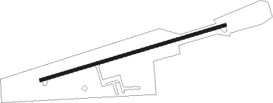
Runway info
| Runway 7 / 25 | ||
| length | 916m (3005ft) | |
| bearing | 80° / 260° | |
| width | 15m (50ft) | |
| surface | asphalt | |
Nearby beacons
| code | identifier | dist | bearing | frequency |
|---|---|---|---|---|
| DGD | DOGWOOD VORTAC | 13.7 | 248° | 109.40 |
| SGF | SPRINGFIELD VORTAC | 36.7 | 288° | 116.90 |
| HUW | DME | 37.8 | 109° | 111.60 |
| BHN | BUCKHORN (FORT LEONARD WOOD) NDB | 42.2 | 42° | 391 |
| TBN | FORNEY (FORT LEONARD WOOD VOR | 43.5 | 38° | 110 |
| MAP | MAPLES TACAN | 48.5 | 61° | 113.40 |
| FLP | DME | 50.2 | 169° | 116.05 |
| SHY | SUNSHINE (KAISER) VOR/DME | 54.8 | 1° | 108.40 |
| HRO | HARRISON VOR/DME | 56.2 | 216° | 112.50 |
Disclaimer
The information on this website is not for real aviation. Use this data with the X-Plane flight simulator only! Data taken with kind consent from X-Plane 12 source code and data files. Content is subject to change without notice.