Jenison - Riverview
Airport details
| Country | United States of America |
| State | Michigan |
| Region | K5 |
| Airspace | Chicago Ctr |
| Municipality | Georgetown Township |
| Elevation | 603ft (184m) |
| Timezone | GMT -5 |
| Coordinates | 42.93672, -85.80576 |
| Magnetic var | |
| Type | land |
| Available since | X-Plane v10.40 |
| ICAO code | 08C |
| IATA code | n/a |
| FAA code | 08C |
Communication
| RIVERVIEW CTAF/UNICOM | 122.900 |
Nearby Points of Interest:
Norton Mound Group
-Hudsonville Christian School Building
-Heartside Historic District
-Exhibitors Building
-Rood Building
-Goodspeed Brothers Building
-Michigan Trust Company Building
-Division Avenue–Plaster Creek Bridge
-Peck Block
-Grand Rapids Savings Bank Building
-Old Grand Rapids City Hall
-Woodbridge N. Ferris Building
-Loraine Building
-Berkey and Gay Furniture Company Factory
-President Gerald R. Ford, Jr. Boyhood Home
-Saint Joseph Seminary
-Third Reformed Church of Grand Rapids, Michigan
-Paddock Place
-Mathias J. Alten House and Studio
-John W. Blodgett Estate
-Grand Rapids, Grand Haven and Muskegon Railway Depot
-Olive Township District No. 1 School
-Spoonville site
-Old Wing Mission
-Holland Old City Hall and Fire Station
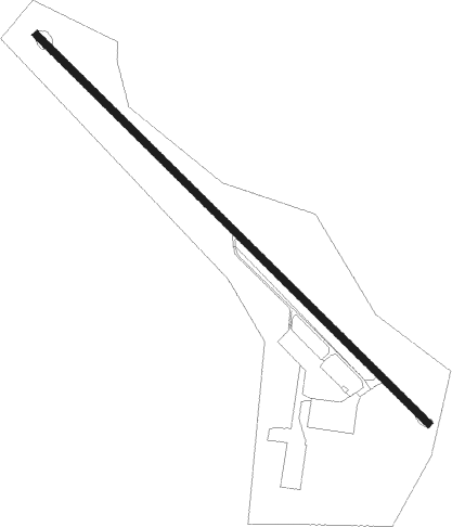
Runway info
| Runway 14 / 32 | ||
| length | 1182m (3878ft) | |
| bearing | 130° / 310° | |
| width | 15m (49ft) | |
| surface | asphalt | |
| displ threshold | 0m (0ft) / 359m (1178ft) | |
Nearby beacons
| code | identifier | dist | bearing | frequency |
|---|---|---|---|---|
| VIO | VICTORY VOR/DME | 16.3 | 116° | 115.95 |
| MKG | MUSKEGON TACAN | 17.3 | 315° | 115.20 |
| GR | KNOBS (GRAND RAPIDS) NDB | 18.9 | 95° | 263 |
| PMM | PULLMAN VOR/DME | 31.1 | 212° | 112.10 |
| HIC | WHITE CLOUD VOR/DME | 38.5 | 8° | 117.60 |
| AZO | KALAMAZOO VOR/DME | 43.4 | 160° | 109 |
| BT | BATOL (BATTLE CREEK) NDB | 44 | 133° | 272 |
| ELX | KEELER VOR/DME | 49.6 | 202° | 116.60 |
| AZ | AUSTN (KALAMAZOO) NDB | 49.8 | 161° | 371 |
Disclaimer
The information on this website is not for real aviation. Use this data with the X-Plane flight simulator only! Data taken with kind consent from X-Plane 12 source code and data files. Content is subject to change without notice.