West Kingston - Richmond Airport
Airport details
| Country | United States of America |
| State | Rhode Island |
| Region | |
| Airspace | Boston Ctr |
| Municipality | Richmond |
| Elevation | 127ft (39m) |
| Timezone | GMT -5 |
| Coordinates | 41.48992, -71.62450 |
| Magnetic var | |
| Type | land |
| Available since | X-Plane v10.40 |
| ICAO code | 08R |
| IATA code | n/a |
| FAA code | 08R |
Communication
| Richmond Airport CTAF/Unicom | 122.800 |
Nearby Points of Interest:
John Hoxsie House
-Usquepaug Road Historic District
-Hillsdale Historic and Archeological District
-Albert S. Potter Octagon House
-Shannock Historic District
-Cottrell House
-Washington County Courthouse
-Joseph Jeffrey House
-Hope Valley
-Henry Eldred Farm
-George Fayerweather Blacksmith Shop
-R. R. Gardner House
-Tootell House
-Gen. Isaac Peace Rodman House
-Red House
-Commodore Oliver Perry Farm
-Lawton's Mill
-William Davis Miller House
-Perry-Carpenter Grist Mill
-Simon Lillibridge Farm
-District Schoolhouse No. 2
-Kenyon's Department Store
-Hale House
-Willow Dell
-Austin Farm Road Agricultural Area
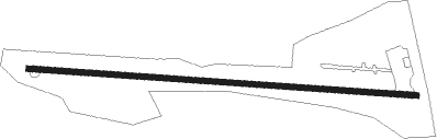
Runway info
| Runway 11 / 29 | ||
| length | 650m (2133ft) | |
| bearing | 96° / 276° | |
| width | 9m (30ft) | |
| surface | asphalt | |
| displ threshold | 0m (0ft) / 44m (144ft) | |
Nearby beacons
| code | identifier | dist | bearing | frequency |
|---|---|---|---|---|
| PVD | PROVIDENCE VOR/DME | 16.5 | 40° | 115.60 |
| ORW | NORWICH VOR/DME | 17.3 | 280° | 110 |
| SEY | SANDY POINT (BLOCK ISLAND VOR/DME | 19.4 | 171° | 117.80 |
| GON | GROTON VOR/DME | 21.5 | 250° | 110.85 |
| PUT | PUTNAM VOR/DME | 29.6 | 335° | 117.40 |
| HFD | HARTFORD VOR/DME | 42.4 | 279° | 114.90 |
| OW | STOGE (NORWOOD) NDB | 43.8 | 38° | 397 |
| HTO | HAMPTON (EAST HAMPTON) VORTAC | 46.4 | 230° | 113.60 |
| CEF | WESTOVER(SPRINGFIELD/CHIC TACAN | 58.6 | 308° | 114 |
| BOS | BOSTON VOR/DME | 59.3 | 36° | 112.70 |
Disclaimer
The information on this website is not for real aviation. Use this data with the X-Plane flight simulator only! Data taken with kind consent from X-Plane 12 source code and data files. Content is subject to change without notice.