Elizabethton - Elizabethton Muni
Airport details
| Country | United States of America |
| State | Tennessee |
| Region | K7 |
| Airspace | Atlanta Ctr |
| Municipality | Elizabethton |
| Elevation | 1589ft (484m) |
| Timezone | GMT -5 |
| Coordinates | 36.37122, -82.17342 |
| Magnetic var | |
| Type | land |
| Available since | X-Plane v10.40 |
| ICAO code | 0A9 |
| IATA code | n/a |
| FAA code | 0A9 |
Communication
| Elizabethton Muni AWOS 3 | 135.675 |
| Elizabethton Muni CTAF/UNICOM | 123.000 |
Nearby Points of Interest:
Simerly-Butler House
-Tipton-Haynes State Historic Site
-John T. Wilder House
-Old Deery Inn
-Bristol Commercial Historic District
-Bristol
-King-Lancaster-McCoy-Mitchell House
-Bristol Warehouse Historic District
-Solar Hill Historic District
-Virginia Hill Historic District
-Virginia Middle School
-Euclid Avenue Historic District (Bristol, Virginia)
-Virginia Intermont College
-Douglass School
-Henry Hoss House
-Jonesborough Historic District
-Elk Park School
-Walnut Grove (Bristol, Virginia)
-Yancey's Tavern
-Maymead Farm
-John N. Peterson Farm
-DeVault Tavern
-Moonlite Drive-In
-Cove Creek High School
-Gate City Historic District
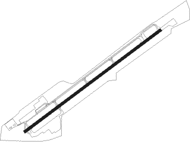
Runway info
| Runway 6 / 24 | ||
| length | 1380m (4528ft) | |
| bearing | 63° / 243° | |
| width | 21m (70ft) | |
| surface | asphalt | |
| displ threshold | 30m (98ft) / 131m (430ft) | |
Nearby beacons
| code | identifier | dist | bearing | frequency |
|---|---|---|---|---|
| HMV | HOLSTON MOUNTAIN VORTAC | 4.4 | 34° | 114.60 |
| TR | MOCCA(BRISTOL-JOHNSON-KINGSPOR NDB | 13 | 322° | 299 |
| BO | BOOIE (BRISTOL) NDB | 15.6 | 275° | 221 |
| JJC | MOUNTAIN CITY NDB | 17 | 83° | 396 |
| BAR | HEMLOCK (BANNER ELK) NDB | 19.3 | 127° | 320 |
| GZG | GLADE SPRING (BLACKFORD) VOR/DME | 27.6 | 12° | 110.20 |
| RVN | ROGERSVILLE NDB | 34.7 | 277° | 329 |
| JUH | ASHEE (JEFFERSON) NDB | 41.3 | 86° | 410 |
| FIQ | FIDDLERS (MORGANTON) NDB | 46.5 | 143° | 391 |
| IM | KEANS (ASHEVILLE) NDB | 54.2 | 206° | 357 |
| BZM | BARRETTS MOUNTAIN (HICKOR VOR/DME | 54.3 | 118° | 113.75 |
| HK | TAWBA (HICKORY) NDB | 54.8 | 124° | 332 |
| SOT | SNOWBIRD VORTAC | 55.1 | 237° | 108.80 |
| SUG | SUGARLOAF MT. (ASHEVILLE) VORTAC | 58.1 | 186° | 112.20 |
| BLF | BLUEFIELD VOR/DME | 73.2 | 46° | 110 |
Instrument approach procedures
| runway | airway (heading) | route (dist, bearing) |
|---|---|---|
| RW06 | CABYA (63°) | CABYA 5300ft ACABE (5mi, 63°) 4600ft |
| RW06 | TAKEN (83°) | TAKEN CABYA (6mi, 146°) 5300ft ACABE (5mi, 63°) 4600ft |
| RNAV | ACABE 4600ft ZURVI (3mi, 63°) 3700ft 0A9 (6mi, 63°) 1592ft (5027mi, 114°) 1993ft CABYA (5038mi, 294°) 5300ft CABYA (turn) |
Disclaimer
The information on this website is not for real aviation. Use this data with the X-Plane flight simulator only! Data taken with kind consent from X-Plane 12 source code and data files. Content is subject to change without notice.