Adel - Cook County
Airport details
| Country | United States of America |
| State | Georgia |
| Region | K7 |
| Airspace | Jacksonville Ctr |
| Municipality | Adel |
| Elevation | 232ft (71m) |
| Timezone | GMT -5 |
| Coordinates | 31.13712, -83.45382 |
| Magnetic var | |
| Type | land |
| Available since | X-Plane v10.40 |
| ICAO code | 15J |
| IATA code | n/a |
| FAA code | n/a |
Communication
Nearby Points of Interest:
Cook County Courthouse
-SOWEGA Building
-United States Post Office–Adel, Georgia
-William G. Harrison House
-Berrien County Courthouse
-Old Berrien County Jail
-Colquitt County Jail
-Moultrie Commercial Historic District
-Colquitt County Courthouse
-Carnegie Library of Moultrie
-Colquitt County Arts Center
-Crestwood
-James W. Coleman House
-Alapaha Colored School
-Brookwood North Historic District
-Tifton Commercial Historic District
-Tift County Courthouse
-Tifton Residential Historic District
-East End Historic District
-Barber-Pittman House
-Converse-Dalton House
-Lowndes County Courthouse
-Lowndes County Historical Society Museum
-First Presbyterian Church
-Southside Historic District
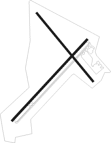
Runway info
Runway 5 / 23  | ||
| length | 1527m (5010ft) | |
| bearing | 52° / 232° | |
| width | 30m (100ft) | |
| surface | asphalt | |
| blast zone | 58m (190ft) / 0m (0ft) | |
| Runway 15 / 33 | ||
| length | 1223m (4012ft) | |
| bearing | 141° / 321° | |
| width | 30m (100ft) | |
| surface | asphalt | |
| displ threshold | 184m (604ft) / 109m (358ft) | |
Nearby beacons
| code | identifier | dist | bearing | frequency |
|---|---|---|---|---|
| VAD | MOODY (VALDOSTA) TACAN | 17.1 | 124° | 113.30 |
| IFM | TIFT MYERS (TIFTON) VOR | 17.6 | 353° | 112.50 |
| MGR | DME | 18.3 | 261° | 108.80 |
| GTP | PATON (THOMASVILLE) NDB | 22 | 244° | 245 |
| OTK | VALDOSTA VOR/DME | 23.2 | 154° | 114.80 |
| SUR | FITZGERALD NDB | 29.7 | 19° | 362 |
| OWC | COFFEE COUNTY (DOUGLAS) NDB | 31.6 | 63° | 390 |
| HOE | HOMERVILLE NDB | 35.4 | 97° | 209 |
| GEF | GREENVILLE VORTAC | 39 | 209° | 109 |
| CYR | CAIDY (CAIRO) NDB | 39.2 | 251° | 338 |
| AYS | WAYCROSS VORTAC | 46.7 | 82° | 110.20 |
| PZD | PECAN (ALBANY) VOR/DME | 53 | 302° | 116.10 |
| AMG | ALMA VORTAC | 54.1 | 67° | 115.10 |
| OHY | CONEY (CORDELE) NDB | 55.7 | 335° | 400 |
| SZW | SEMINOLE VORTAC | 58.8 | 238° | 117.50 |
| TAY | TAYLOR VORTAC | 60 | 125° | 112.90 |
| AZE | HAZLEHURST NDB | 60.7 | 47° | 414 |
| EZM | EASTMAN NDB | 61.6 | 17° | 366 |
| MQW | MC RAE NDB | 64.5 | 31° | 280 |
| ACJ | SOUTHER (AMERICUS) NDB | 69.5 | 323° | 242 |
| LCQ | LAKE CITY NDB | 72.8 | 137° | 204 |
Instrument approach procedures
| runway | airway (heading) | route (dist, bearing) |
|---|---|---|
| RW05 | ARGYL (51°) | ARGYL 2000ft |
| RW05 | WUBSU (80°) | WUBSU ARGYL (9mi, 119°) 2000ft |
| RNAV | ARGYL 2000ft UBEDY (6mi, 52°) 2000ft 15J (6mi, 51°) 279ft (5069mi, 110°) 534ft ZASIT (5065mi, 291°) IBEBE (15mi, 13°) 3000ft IBEBE (turn) | |
| RW23 | IBEBE (204°) | IBEBE WUMOM (11mi, 171°) 3000ft |
| RW23 | WUBSU (80°) | WUBSU WUMOM (27mi, 69°) 3000ft WUMOM (turn) 3000ft |
| RNAV | WUMOM 3000ft ZASIT (6mi, 232°) 2000ft JUXEL (2mi, 232°) 1220ft 15J (3mi, 232°) 275ft (5069mi, 110°) 536ft TIGEE (5071mi, 290°) WUBSU (14mi, 267°) 3000ft WUBSU (turn) |
Disclaimer
The information on this website is not for real aviation. Use this data with the X-Plane flight simulator only! Data taken with kind consent from X-Plane 12 source code and data files. Content is subject to change without notice.