Cross Keys
Airport details
| Country | United States of America |
| State | New Jersey |
| Region | K6 |
| Airspace | Washington Ctr |
| Municipality | Monroe Township |
| Elevation | 162ft (49m) |
| Timezone | GMT -5 |
| Coordinates | 39.70724, -75.03603 |
| Magnetic var | |
| Type | land |
| Available since | X-Plane v10.40 |
| ICAO code | 17N |
| IATA code | n/a |
| FAA code | n/a |
Communication
| Cross Keys CTAF/UNICOM | 122.800 |
| Cross Keys PHILY Approach/Departure | 127.350 |
Nearby Points of Interest:
Downer Methodist Episcopal Church
-Hall Street School
-Free Library and Reading Room-Williamstown Memorial Library
-St. Thomas Episcopal Church
-Whitney Mansion
-Pitman Grove
-Solomon Wesley United Methodist Church
-Richwood Methodist Church
-Chew-Powell House
-Jesse Chew House
-Benjamin Clark House
-Long-A-Coming Depot
-Gabreil Daveis Tavern House
-Mullica Hill Historic District
-Glendale Methodist Episcopal Church
-David V. Smith House
-Carpenter Street School
-Thompson House
-G. G. Green's Block
-Hunter-Lawrence-Jessup House
-Woodbury Friends' Meetinghouse
-Col. Joseph Ellis House
-St. Peter's Episcopal Church
-Hinchman-Lippincott House
-Isaac Glover House
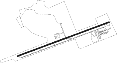
Runway info
| Runway 9 / 27 | ||
| length | 1068m (3504ft) | |
| bearing | 78° / 258° | |
| width | 15m (50ft) | |
| surface | asphalt | |
| displ threshold | 0m (0ft) / 63m (207ft) | |
Nearby beacons
| code | identifier | dist | bearing | frequency |
|---|---|---|---|---|
| VCN | CEDAR LAKE (MILLVILLE) VOR/DME | 10.6 | 158° | 115.20 |
| OOD | WOODSTOWN VORTAC | 13 | 255° | 112.80 |
| RNB | RAINBOW (MILLVILLE) NDB | 17.9 | 199° | 363 |
| ACY | ATLANTIC CITY VORTAC | 26 | 119° | 108.60 |
| DQO | DUPONT (WILMINGTON) VORTAC | 26.4 | 267° | 114 |
| GXU | MC GUIRE (WRIGHTSTOWN) VORTAC | 27.2 | 55° | 110.60 |
| ING | AMBLER NDB | 27.6 | 329° | 275 |
| IL | HADIN (WILMINGTON) NDB | 27.7 | 258° | 248 |
| CYN | COYLE VORTAC | 28.6 | 80° | 113.40 |
| MXE | MODENA VORTAC | 31.9 | 288° | 113.20 |
| ARD | YARDLEY VOR/DME | 33.3 | 13° | 108.20 |
| ENO | SMYRNA (KENTON) VORTAC | 36.2 | 225° | 111.40 |
| NEL | LAKEHURST TACAN | 37.1 | 64° | 111.80 |
| NEL | LAKEHURST NDB | 38.1 | 64° | 396 |
| SIE | SEA ISLE VORTAC | 38.3 | 159° | 114.80 |
| RBV | ROBBINSVILLE VORTAC | 38.7 | 48° | 113.80 |
| PTW | POTTSTOWN VORTAC | 39.2 | 314° | 116.50 |
| DOV | DOVER TACAN | 39.9 | 217° | 110 |
| COL | COLTS NECK VOR/DME | 54.2 | 55° | 115.40 |
| SBJ | SOLBERG VOR/DME | 54.3 | 19° | 112.90 |
| ATR | WATERLOO VOR/DME | 54.5 | 191° | 112.60 |
| ETX | EAST TEXAS VOR/DME | 60.3 | 323° | 110.20 |
Disclaimer
The information on this website is not for real aviation. Use this data with the X-Plane flight simulator only! Data taken with kind consent from X-Plane 12 source code and data files. Content is subject to change without notice.