Hector - Hector Muni
Airport details
| Country | United States of America |
| State | Minnesota |
| Region | |
| Airspace | Minneapolis Ctr |
| Municipality | Hector |
| Elevation | 1077ft (328m) |
| Timezone | GMT -6 |
| Coordinates | 44.73348, -94.71619 |
| Magnetic var | |
| Type | land |
| Available since | X-Plane v10.40 |
| ICAO code | 1D6 |
| IATA code | n/a |
| FAA code | 1D6 |
Communication
| Hector Muni CTAF | 122.800 |
Nearby Points of Interest:
Renville County Courthouse and Jail
-Heins Block
-Gibbon Village Hall
-Birch Coulee Battlefield
-Lower Sioux Agency
-Fort Ridgely State Park CCC/Rustic Style Historic Resources
-St. Cornelia's Episcopal Church
-Fort Ridgely
-Merton S. Goodnow House
-Brightwood Beach Cottage
-Litchfield Opera House
-Joseph Brown House Ruins
-New Ulm Oil Company Service Station
-Sacred Heart Public School
-Universal Laboratories Building
-Boesch, Hummel, and Maltzahn Block
-Flandrau State Park CCC/WPA/Rustic Style Historic Resources
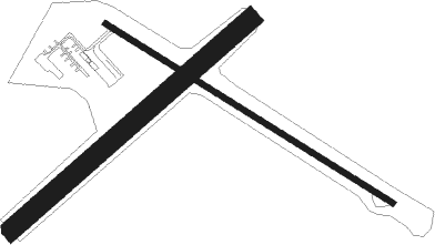
Runway info
Runway 12 / 30  | ||
| length | 844m (2769ft) | |
| bearing | 118° / 298° | |
| width | 15m (50ft) | |
| surface | asphalt | |
| Runway 05 / 23 | ||
| length | 793m (2602ft) | |
| bearing | 62° / 242° | |
| width | 50m (165ft) | |
| surface | grass | |
Nearby beacons
| code | identifier | dist | bearing | frequency |
|---|---|---|---|---|
| RWF | REDWOOD FALLS VOR/DME | 23.7 | 237° | 113.30 |
| DWN | DARWIN VORTAC | 24 | 37° | 109 |
| BDH | WILLMAR VOR/DME | 28.9 | 313° | 113.70 |
| MVE | MONTEVIDEO VOR/DME | 44.7 | 284° | 111.60 |
| MKT | MANKATO VOR/DME | 46.2 | 123° | 110.80 |
| ST | HUSSK (ST CLOUD) NDB | 54.8 | 45° | 342 |
| STC | SAINT CLOUD VOR/DME | 56.3 | 39° | 112.10 |
Disclaimer
The information on this website is not for real aviation. Use this data with the X-Plane flight simulator only! Data taken with kind consent from X-Plane 12 source code and data files. Content is subject to change without notice.