Gallatin - Lake Viking
Airport details
| Country | United States of America |
| State | Missouri |
| Region | |
| Airspace | Kansas City Ctr |
| Municipality | Daviess County |
| Elevation | 937ft (286m) |
| Timezone | GMT -6 |
| Coordinates | 39.93603, -94.07555 |
| Magnetic var | |
| Type | land |
| Available since | X-Plane v10.40 |
| ICAO code | 1MO3 |
| IATA code | n/a |
| FAA code | 1MO3 |
Communication
Nearby Points of Interest:
Daviess County Rotary Jail and Sheriff's Residence
-A. Taylor Ray House
-Daviess County Courthouse
-DeKalb County Courthouse
-Gentry County Courthouse
-Carnegie Library of Albany
-Trenton High School
-Courthouse Square Historic District
-Chillicothe Commercial Historic District
-Grace Episcopal Church
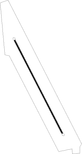
Runway info
| Runway 15 / 33 | ||
| length | 842m (2762ft) | |
| bearing | 151° / 331° | |
| width | 10m (33ft) | |
| surface | asphalt | |
Nearby beacons
| code | identifier | dist | bearing | frequency |
|---|---|---|---|---|
| BQS | BRAYMER VOR/DME | 20.5 | 147° | 115.35 |
| AZN | AMAZON (SAINT JOSEPH) NDB | 38.4 | 266° | 233 |
| STJ | SAINT JOSEPH (ST JOSEPH) VORTAC | 39.1 | 272° | 115.50 |
| LMN | LAMONI VOR/DME | 39.9 | 9° | 116.70 |
| ST | TARIO (ST JOSEPH) NDB | 41.4 | 253° | 260 |
| MCI | KANSAS CITY VORTAC | 49.6 | 225° | 113.25 |
| ANX | NAPOLEON VORTAC | 50.5 | 184° | 114 |
| RN | HUGGY (KANSAS CITY) NDB | 52.3 | 231° | 416 |
Disclaimer
The information on this website is not for real aviation. Use this data with the X-Plane flight simulator only! Data taken with kind consent from X-Plane 12 source code and data files. Content is subject to change without notice.