Edgewood - Sandia Airpark Estates East
Airport details
| Country | United States of America |
| State | New Mexico |
| Region | K2 |
| Airspace | Albuquerque Ctr |
| Municipality | Edgewood |
| Elevation | 6548ft (1996m) |
| Timezone | GMT -7 |
| Coordinates | 35.09461, -106.16456 |
| Magnetic var | |
| Type | land |
| Available since | X-Plane v10.40 |
| ICAO code | 1N1 |
| IATA code | n/a |
| FAA code | n/a |
Communication
| Sandia Airpark Estates East CTAF/UNICOM | 122.800 |
Nearby Points of Interest:
Moriarty Eclipse Windmill
-San Antonito Church and Cemetery
-San Lazaro archaeological site
-Enchanted Mesa Trading Post
-Albuquerque Veterans Administration Medical Center
-Solar Building
-Davis House
-Nob Hill Business Center
-Hendren Building
-William J. Leverett House
-Ernie Pyle House/Library
-Rumaldo Chavez House
-Jones Motor Company
-Werner-Gilchrist House
-Zimmerman Library
-Jonson Gallery and House
-President's House
-Pig & Calf Lunch
-Carlisle Gymnasium
-Scholes Hall
-Sara Raynolds Hall
-Old Albuquerque Municipal Airport Building
-Art Annex
-Juan Antonio Garcia House
-Hodgin Hall
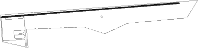
Runway info
| Runway 9 / 27 | ||
| length | 1579m (5180ft) | |
| bearing | 90° / 270° | |
| width | 9m (30ft) | |
| surface | asphalt | |
| displ threshold | 216m (709ft) / 0m (0ft) | |
Nearby beacons
| code | identifier | dist | bearing | frequency |
|---|---|---|---|---|
| OTO | OTTO VOR | 11.3 | 96° | 114 |
| SAF | SANTA FE VORTAC | 27.2 | 13° | 110.60 |
| AE | DUDLE (ALBUQUERQUE) NDB | 27.9 | 283° | 351 |
| ABQ | ALBUQUERQUE VORTAC | 32.1 | 266° | 113.20 |
| BRG | DME | 42.4 | 236° | 114.75 |
| CNX | CORONA VORTAC | 49.8 | 146° | 115.50 |
| ONM | SOCORRO VORTAC | 55.7 | 221° | 116.80 |
Disclaimer
The information on this website is not for real aviation. Use this data with the X-Plane flight simulator only! Data taken with kind consent from X-Plane 12 source code and data files. Content is subject to change without notice.