Priest River - Priest River Muni
Airport details
| Country | United States of America |
| State | Idaho |
| Region | |
| Airspace | Seattle Ctr |
| Municipality | Priest River |
| Elevation | 2187ft (667m) |
| Timezone | GMT -8 |
| Coordinates | 48.18734, -116.91336 |
| Magnetic var | |
| Type | land |
| Available since | X-Plane v10.40 |
| ICAO code | 1S6 |
| IATA code | n/a |
| FAA code | 1S6 |
Communication
| Priest River Muni CTAF | 122.900 |
Nearby Points of Interest:
Priest River Commercial Core Historic District
-Dr. John and Viola Phillips House and Office
-Dover Church
-Amanda Nesbitt House
-Sandpoint Historic District
-Mount Spokane Vista House
-John A. Finch Caretaker's House
-Clark House
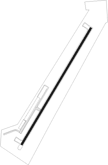
Runway info
| Runway 1 / 19 | ||
| length | 900m (2953ft) | |
| bearing | 47° / 227° | |
| width | 15m (48ft) | |
| surface | asphalt | |
Nearby beacons
| code | identifier | dist | bearing | frequency |
|---|---|---|---|---|
| SZT | SANDPOE (SANDPOINT) NDB | 15.3 | 74° | 264 |
| DPY | DEER PARK NDB | 24.4 | 247° | 365 |
| COE | COEUR D'ALENE VOR/DME | 25.1 | 167° | 108.80 |
| ION | IONE NDB | 37.1 | 316° | 379 |
| SKA | FAIRCHILD (SPOKANE) TACAN | 45.9 | 232° | 111.40 |
| GEG | SPOKANE VORTAC | 47.1 | 229° | 115.50 |
Disclaimer
The information on this website is not for real aviation. Use this data with the X-Plane flight simulator only! Data taken with kind consent from X-Plane 12 source code and data files. Content is subject to change without notice.