New Hampton - New Hampton Muni.
Airport details
| Country | United States of America |
| State | Iowa |
| Region | |
| Airspace | Minneapolis Ctr |
| Municipality | Chickasaw County |
| Elevation | 1171ft (357m) |
| Timezone | GMT -6 |
| Coordinates | 43.09208, -92.34474 |
| Magnetic var | |
| Type | land |
| Available since | X-Plane v10.40 |
| ICAO code | 1Y5 |
| IATA code | n/a |
| FAA code | 1Y5 |
Communication
| New Hampton Muni. CTAF | 122.900 |
Nearby Points of Interest:
Chickasaw County Courthouse
-Bohemian Savings Bank
-Charles Walter Hart House
-A. B. C. Dodd House
-Lucius and Maria Clinton Lane House
-Dr. Salsbury's Laboratories, Main Office and Production Laboratory Building
-Main Street Bridge
-Charles Henry Parr House
-Floyd County Court House
-Alvin Miller House
-Sherman Nursery Company Historic District
-Sumner High School
-Wenzil Taylor Building
-James C. Fellows House
-Howard County Courthouse
-West Auburn Bridge
-Harmon and LeValley Northwest Historic District
-Eldorado Bridge
-Lidtke Mill
-Bremer County Court House
-Old Main
-Waverly Municipal Hydroelectric Powerhouse
-Waverly House
-Old Fourth Ward Southeast Historic District
-Sturdevant Southwest Historic District
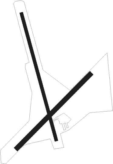
Runway info
Runway 17 / 35  | ||
| length | 885m (2904ft) | |
| bearing | 165° / 345° | |
| width | 23m (75ft) | |
| surface | asphalt | |
| Runway 04 / 22 | ||
| length | 701m (2300ft) | |
| bearing | 58° / 238° | |
| width | 32m (105ft) | |
| surface | grass | |
Nearby beacons
| code | identifier | dist | bearing | frequency |
|---|---|---|---|---|
| IY | CHUKK (CHARLES CITY) NDB | 16.9 | 276° | 417 |
| ALO | WATERLOO VOR/DME | 32.2 | 186° | 112.20 |
| UKN | DME | 37.1 | 77° | 116.60 |
| JAY | AUSTIN VOR/DME | 38.3 | 310° | 108.20 |
| IIB | WAPSIE (INDEPENDENCE) NDB | 42.1 | 148° | 206 |
| RST | ROCHESTER VOR/DME | 42.9 | 340° | 112 |
| MC | SURFF (MASON CITY) NDB | 43.1 | 268° | 348 |
| MCW | MASON CITY VOR/DME | 43.2 | 270° | 114.90 |
| ODI | NODINE VORTAC | 62.3 | 47° | 117.90 |
| JWJ | ELMWOOD (MARSHALTOWN) VOR/DME | 63.9 | 210° | 109.40 |
| OW | TONNA (OWATONNA) NDB | 68.7 | 320° | 379 |
Disclaimer
The information on this website is not for real aviation. Use this data with the X-Plane flight simulator only! Data taken with kind consent from X-Plane 12 source code and data files. Content is subject to change without notice.