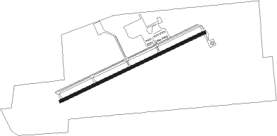
Live Oak - Suwannee County
Airport details
| Country | United States of America |
| State | Florida |
| Region | K7 |
| Airspace | Jacksonville Ctr |
| Municipality | Suwannee County |
| Elevation | 104ft (32m) |
| Timezone | GMT -5 |
| Coordinates | 30.30039, -83.02439 |
| Magnetic var | |
| Type | land |
| Available since | X-Plane v10.40 |
| ICAO code | 24J |
| IATA code | n/a |
| FAA code | n/a |
Communication
| Suwannee County AWOS 3 | 118.225 |
| Suwannee County CTAF/UNICOM | 122.800 |
Nearby Points of Interest:
George Allison House
-Bishop B. Blackwell House
-Suwannee County Courthouse
-Union Depot and Atlantic Coast Line Freight Station
-Old Live Oak City Hall
-Dr. Price House
-Hull-Hawkins House
-White Springs Historic District
-Old Hamilton County Jail
-Johns House
-Falling Creek Methodist Church and Cemetery
-Columbia County High School
-Horace Duncan House
-Lake City Historic Commercial District
-T. G. Henderson House
-Lake Isabella Historic Residential District
-Dial-Goza House
-Dr. Chandler Holmes Smith House
-Wardlaw-Smith House
-Jordan-Beggs House
-Corbett Farm
-Ewell Brown General Store
-Fort White Public School Historic District
-South Brooksville Avenue Historic District
-Sikes House
Nearby beacons
| code | identifier | dist | bearing | frequency |
|---|---|---|---|---|
| LCQ | LAKE CITY NDB | 24.1 | 104° | 204 |
| TAY | TAYLOR VORTAC | 27.3 | 67° | 112.90 |
| OTK | VALDOSTA VOR/DME | 31.7 | 332° | 114.80 |
| VAD | MOODY (VALDOSTA) TACAN | 40.5 | 346° | 113.30 |
| GEF | GREENVILLE VORTAC | 42 | 288° | 109 |
| CTY | CROSS CITY VORTAC | 42.1 | 182° | 112 |
| HOE | HOMERVILLE NDB | 47.1 | 18° | 209 |
| GNV | GATORS VORTAC | 53.4 | 129° | 116.20 |
| GTP | PATON (THOMASVILLE) NDB | 57.2 | 309° | 245 |
| GN | WYNDS (GAINESVILLE) NDB | 58.2 | 126° | 269 |
| MGR | DME | 61.8 | 315° | 108.80 |
| AYS | WAYCROSS VORTAC | 63 | 26° | 110.20 |
Instrument approach procedures
| runway | airway (heading) | route (dist, bearing) |
|---|---|---|
| RW07 | EJSEV (72°) | EJSEV 3000ft |
| RNAV | EJSEV 3000ft YEVUR (6mi, 72°) 1800ft WIRAT (3mi, 72°) 960ft 24J (3mi, 72°) 141ft (5044mi, 110°) 460ft YAGUD (5033mi, 290°) 3000ft YAGUD (turn) | |
| RW25 | YAGUD (252°) | YAGUD 3000ft |
| RNAV | YAGUD 3000ft PUYPO (6mi, 252°) 1800ft ZUDVO (3mi, 252°) 940ft 24J (3mi, 252°) 155ft (5044mi, 110°) 353ft EJSEV (5054mi, 290°) 3000ft EJSEV (turn) |
Disclaimer
The information on this website is not for real aviation. Use this data with the X-Plane flight simulator only! Data taken with kind consent from X-Plane 12 source code and data files. Content is subject to change without notice.