Kent City - Wilderness Airpark
Airport details
| Country | United States of America |
| State | Michigan |
| Region | |
| Airspace | Chicago Ctr |
| Municipality | Tyrone Township |
| Elevation | 785ft (239m) |
| Timezone | GMT -5 |
| Coordinates | 43.24451, -85.71667 |
| Magnetic var | |
| Type | land |
| Available since | X-Plane v10.40 |
| ICAO code | 24M |
| IATA code | n/a |
| FAA code | 24M |
Communication
| Wilderness Airpark CTAF | 122.900 |
Nearby Points of Interest:
Elk Rapids Township Hall
-Grand Rapids, Grand Haven and Muskegon Railway Depot
-Berkey and Gay Furniture Company Factory
-Fremont High School
-Exhibitors Building
-Old Grand Rapids City Hall
-Goodspeed Brothers Building
-Rood Building
-Woodbridge N. Ferris Building
-Michigan Trust Company Building
-Grand Rapids Savings Bank Building
-Peck Block
-Loraine Building
-Third Reformed Church of Grand Rapids, Michigan
-Mathias J. Alten House and Studio
-Heartside Historic District
-Paddock Place
-John W. Blodgett Estate
-President Gerald R. Ford, Jr. Boyhood Home
-Norton Mound Group
-Saint Joseph Seminary
-Division Avenue–Plaster Creek Bridge
-Spoonville site
-Greenville Downtown Historic District
-Battle Point Site
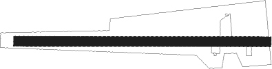
Runway info
| Runway 09 / 27 | ||
| length | 771m (2530ft) | |
| bearing | 93° / 273° | |
| width | 30m (100ft) | |
| surface | grass | |
| displ threshold | 164m (538ft) / 102m (335ft) | |
Nearby beacons
| code | identifier | dist | bearing | frequency |
|---|---|---|---|---|
| MKG | MUSKEGON TACAN | 14.8 | 257° | 115.20 |
| HIC | WHITE CLOUD VOR/DME | 19.8 | 0° | 117.60 |
| GR | KNOBS (GRAND RAPIDS) NDB | 25.6 | 136° | 263 |
| VIO | VICTORY VOR/DME | 29.1 | 154° | 115.95 |
| MOP | MOUNT PLEASANT VOR/DME | 48.3 | 69° | 110.60 |
| PMM | PULLMAN VOR/DME | 49.7 | 207° | 112.10 |
| BT | BATOL (BATTLE CREEK) NDB | 57.9 | 149° | 272 |
| MA | WEXOR (CADILLAC) NDB | 60 | 10° | 336 |
Disclaimer
The information on this website is not for real aviation. Use this data with the X-Plane flight simulator only! Data taken with kind consent from X-Plane 12 source code and data files. Content is subject to change without notice.