Mecosta - Mecosta Morton
Airport details
| Country | United States of America |
| State | Michigan |
| Region | |
| Airspace | Minneapolis Ctr |
| Municipality | Morton Township |
| Elevation | 1020ft (311m) |
| Timezone | GMT -5 |
| Coordinates | 43.63033, -85.26476 |
| Magnetic var | |
| Type | land |
| Available since | X-Plane v10.40 |
| ICAO code | 27C |
| IATA code | n/a |
| FAA code | 27C |
Communication
| Mecosta Morton CTAF | 122.900 |
Nearby Points of Interest:
Sherman City Union Church
-Nisbett Building
-Fairman Building
-Mount Pleasant Indian Industrial Boarding School
-Michigan Condensed Milk Factory
-George and Martha Hitchcock House
-Mount Pleasant Downtown Historic District
-Doughty House (Mount Pleasant, Michigan)
-Giles Gilbert House
-Elk Rapids Township Hall
-Lincoln Road–Pine River Bridge
-MacLachlan Sanitarium
-Greenville Downtown Historic District
-Idlewild
-Marlborough Historic District
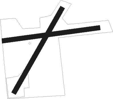
Runway info
Runway 09 / 27  | ||
| length | 616m (2021ft) | |
| bearing | 88° / 268° | |
| width | 30m (100ft) | |
| surface | grass | |
| displ threshold | 166m (545ft) / 0m (0ft) | |
| Runway 03 / 21 | ||
| length | 613m (2011ft) | |
| bearing | 43° / 223° | |
| width | 30m (100ft) | |
| surface | grass | |
| displ threshold | 229m (751ft) / 138m (453ft) | |
Nearby beacons
| code | identifier | dist | bearing | frequency |
|---|---|---|---|---|
| HIC | WHITE CLOUD VOR/DME | 19.9 | 263° | 117.60 |
| MOP | MOUNT PLEASANT VOR/DME | 22.9 | 91° | 110.60 |
| MA | WEXOR (CADILLAC) NDB | 38.4 | 335° | 336 |
| MKG | MUSKEGON TACAN | 43.6 | 239° | 115.20 |
| GR | KNOBS (GRAND RAPIDS) NDB | 44.4 | 189° | 263 |
| VIO | VICTORY VOR/DME | 51.6 | 195° | 115.95 |
| MB | JEPOT (MANISTEE) NDB | 54 | 306° | 254 |
| MBL | DME | 57.5 | 303° | 111.40 |
Disclaimer
The information on this website is not for real aviation. Use this data with the X-Plane flight simulator only! Data taken with kind consent from X-Plane 12 source code and data files. Content is subject to change without notice.