Palatka - Palatka Muni Lt Kay Larkin Field
Airport details
| Country | United States of America |
| State | Florida |
| Region | K7 |
| Airspace | Jacksonville Ctr |
| Municipality | Palatka |
| Elevation | 47ft (14m) |
| Timezone | GMT -5 |
| Coordinates | 29.65838, -81.68951 |
| Magnetic var | |
| Type | land |
| Available since | X-Plane v10.40 |
| ICAO code | 28J |
| IATA code | n/a |
| FAA code | n/a |
Communication
| Palatka MUNI LT Kay Larkin Field CTAF/UNICOM | 122.800 |
| Palatka MUNI LT Kay Larkin Field JACKSONVILLE Approach/Departure | 118.175 |
Nearby Points of Interest:
Palatka South Historic District
-Palatka North Historic District
-Tenney House and Groveland Hotel
-Hastings Community Center
-Hastings High School
-Interlachen Hall
-Sanchez Homestead
-Mount Royal
-James W. Townsend House
-Orange Springs Methodist Episcopal Church and Cemetery
-Hubbard House
-Crescent City Historic District
-Kerr City Historic District
-Morgan-Townsend House
-Dixie Highway
-Melrose Historic District
-Clay County Courthouse
-Green Cove Springs Historic District
-St. Mary's Episcopal Church
-Memorial Home Community Historic District
-Grace United Methodist Church
-St. Benedict the Moor School
-Markland
-Xavier Lopez House
-Sanchez Powder House Site
Runway info
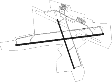
Runway 9 / 27  | ||
| length | 1826m (5991ft) | |
| bearing | 88° / 268° | |
| width | 30m (100ft) | |
| surface | asphalt | |
| displ threshold | 0m (0ft) / 137m (449ft) | |
| Runway 17 / 35 | ||
| length | 1072m (3517ft) | |
| bearing | 164° / 344° | |
| width | 23m (75ft) | |
| surface | asphalt | |
| blast zone | 92m (302ft) / 92m (302ft) | |
Nearby beacons
| code | identifier | dist | bearing | frequency |
|---|---|---|---|---|
| RYD | REYNOLDS (GREEN COVE SPRINGS) NDB | 18.6 | 6° | 338 |
| GN | WYNDS (GAINESVILLE) NDB | 25.1 | 271° | 269 |
| SGJ | SAINT AUGUSTINE VOR/DME | 25.9 | 50° | 109.40 |
| GNV | GATORS VORTAC | 30.5 | 273° | 116.20 |
| NIP | JACKSONVILLE TACAN | 34.6 | 1° | 108.20 |
| NZC | CECIL TACAN | 35 | 342° | 114.10 |
| OMN | ORMOND BEACH VORTAC | 36.9 | 122° | 112.60 |
| OCF | OCALA VORTAC | 40.2 | 228° | 113.70 |
| CRG | CRAIG (JACKSONVILLE) VORTAC | 41.9 | 15° | 114.50 |
| NRB | MAYPORT TACAN | 45.9 | 20° | 111.40 |
| JA | DINNS (JACKSONVILLE) NDB | 48.7 | 352° | 344 |
| LCQ | LAKE CITY NDB | 56 | 301° | 204 |
| TAY | TAYLOR VORTAC | 67.7 | 314° | 112.90 |
Instrument approach procedures
| runway | airway (heading) | route (dist, bearing) |
|---|---|---|
| RW09 | FIKUK (88°) | FIKUK 3000ft |
| RW09 | HESOV (69°) | HESOV FIKUK (5mi, 357°) 3000ft |
| RW09 | JUHRA (106°) | JUHRA FIKUK (5mi, 177°) 3000ft |
| RNAV | FIKUK 3000ft CIXOM (6mi, 88°) 2000ft WUGUG (3mi, 88°) 1000ft 28J (3mi, 88°) 72ft (4972mi, 110°) 314ft TOHCI (4959mi, 290°) 3000ft TOHCI (turn) | |
| RW27 | TOHCI (268°) | TOHCI 3000ft |
| RW27 | WOKUR (287°) | WOKUR 3000ft TOHCI (5mi, 357°) 3000ft |
| RW27 | ZOTUL (249°) | ZOTUL 3000ft TOHCI (5mi, 177°) 3000ft |
| RNAV | TOHCI 3000ft NIDRE (6mi, 268°) 2000ft HURIV (3mi, 268°) 1000ft 28J (3mi, 268°) 71ft (4972mi, 110°) 354ft FIKUK (4985mi, 290°) 3000ft FIKUK (turn) |
Disclaimer
The information on this website is not for real aviation. Use this data with the X-Plane flight simulator only! Data taken with kind consent from X-Plane 12 source code and data files. Content is subject to change without notice.