Oakes - Oakes Muni
Airport details
| Country | United States of America |
| State | North Dakota |
| Region | K3 |
| Airspace | Minneapolis Ctr |
| Municipality | Dickey County |
| Elevation | 1333ft (406m) |
| Timezone | GMT -6 |
| Coordinates | 46.17311, -98.07989 |
| Magnetic var | |
| Type | land |
| Available since | X-Plane v10.40 |
| ICAO code | 2D5 |
| IATA code | n/a |
| FAA code | n/a |
Communication
| Oakes Muni CTAF | 122.900 |
Nearby Points of Interest:
Oakes Post Office
-Klein and Sutmar Block
-LaMoure County Courthouse
-Dickey County Courthouse
-Ellendale Opera House
-T. J. Walker Historic District
-Savo Hall
-Ransom County Courthouse
-Lisbon Post Office
-Lisbon Bridge (Lisbon, North Dakota)
-Marshall County Courthouse
-Martilla-Pettingel and Gorder General Merchandise Store
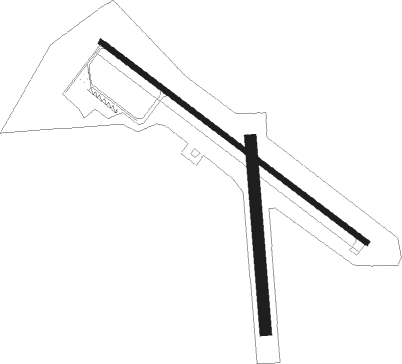
Runway info
Runway 12 / 30  | ||
| length | 1069m (3507ft) | |
| bearing | 122° / 302° | |
| width | 18m (60ft) | |
| surface | asphalt | |
| Runway 17 / 35 | ||
| length | 611m (2005ft) | |
| bearing | 180° / 0° | |
| width | 37m (120ft) | |
| surface | grass | |
Nearby beacons
| code | identifier | dist | bearing | frequency |
|---|---|---|---|---|
| ABR | ABERDEEN VOR/DME | 46.9 | 201° | 113 |
| AB | RENEY (ABERDEEN) NDB | 48.3 | 198° | 203 |
| JMS | JAMESTOWN VOR/DME | 51.9 | 322° | 114.50 |
Instrument approach procedures
| runway | airway (heading) | route (dist, bearing) |
|---|---|---|
| RW30 | EVUKY (285°) | EVUKY JEXEG (9mi, 267°) 3500ft |
| RW30 | OPILY (6°) | OPILY ICEFU (19mi, 32°) 5000ft JEXEG (9mi, 32°) 3500ft |
| RW30 | WODTY (68°) | WODTY ICEFU (23mi, 100°) 5000ft JEXEG (9mi, 32°) 3500ft |
| RNAV | JEXEG 3500ft KEVGY (6mi, 302°) 3000ft 2D5 (5mi, 301°) 1365ft (5741mi, 115°) 2000ft EVUKY (5723mi, 295°) 5000ft EVUKY (turn) |
Disclaimer
The information on this website is not for real aviation. Use this data with the X-Plane flight simulator only! Data taken with kind consent from X-Plane 12 source code and data files. Content is subject to change without notice.