Moline - Elk County
Airport details
| Country | United States of America |
| State | Kansas |
| Region | |
| Airspace | Kansas City Ctr |
| Municipality | Elk County |
| Elevation | 1062ft (324m) |
| Timezone | GMT -6 |
| Coordinates | 37.38440, -96.27088 |
| Magnetic var | |
| Type | land |
| Available since | X-Plane v10.40 |
| ICAO code | 2K6 |
| IATA code | n/a |
| FAA code | 2K6 |
Communication
| Elk County CTAF | 122.900 |
Nearby Points of Interest:
Elk Falls Pratt Truss Bridge
-Robertson House (Eureka, Kansas)
-Eureka Atchison, Topeka and Santa Fe Railroad Depot
-Eureka Carnegie Library
-Esch's Spur Bridge
-Union Implement and Hardware Building-Masonic Temple
-Booth Theater
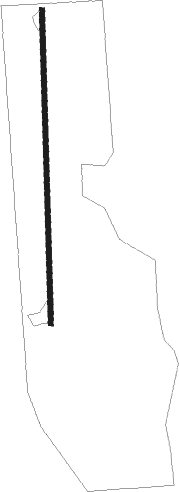
Runway info
| Runway 18 / 36 | ||
| length | 775m (2543ft) | |
| bearing | 184° / 4° | |
| width | 12m (40ft) | |
| surface | asphalt | |
Nearby beacons
| code | identifier | dist | bearing | frequency |
|---|---|---|---|---|
| BV | DEWIE (BARTLESVILLE) NDB | 34.9 | 155° | 201 |
| BVO | BARTLESVILLE VOR/DME | 35.1 | 155° | 117.90 |
| CNU | CHANUTE VOR/DME | 35.3 | 70° | 109.20 |
| IAB | MC CONNELL (WICHITA) TACAN | 49.6 | 283° | 116.50 |
| PN | PONCA (PONCA CITY) NDB | 52 | 236° | 515 |
| EMP | EMPORIA VORTAC | 54.8 | 8° | 112.80 |
| PER | PIONEER (PONCA CITY) VORTAC | 57.3 | 234° | 113.20 |
Disclaimer
The information on this website is not for real aviation. Use this data with the X-Plane flight simulator only! Data taken with kind consent from X-Plane 12 source code and data files. Content is subject to change without notice.