Lake Dallas - Lakeview
Airport details
| Country | United States of America |
| State | Texas |
| Region | |
| Airspace | Ft Worth Ctr |
| Municipality | Lake Dallas |
| Elevation | 535ft (163m) |
| Timezone | GMT -6 |
| Coordinates | 33.13589, -97.01361 |
| Magnetic var | |
| Type | land |
| Available since | X-Plane v10.40 |
| ICAO code | 30F |
| IATA code | n/a |
| FAA code | 30F |
Communication
Nearby Points of Interest:
Thomas J. and Elizabeth Nash Farm
-Allen Water Station
-Ruth Paine Home
-Heard-Craig House
-Highland Park Village
-Fred Florence Hall
-Perkins Administration Building
-Dallas Hall
-Hyer Hall
-Snider Hall
-Parkland Memorial Hospital
-Number 4 Hook and Ladder Company
-Jacob and Eliza Spake House
-Central Congregational Church
-Greenway Parks Historic District
-Swiss Avenue, Dallas
-Ronald Kirk Bridge
-Alfred Horatio Belo House
-Mosaic Dallas
-Texas School Book Depository
-Munger Place Historic District, Dallas
-Republic Center
-Elm Place
-Dallas County Courthouse
-Wilson Block
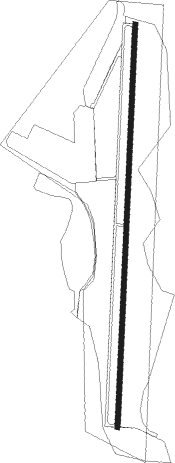
Runway info
| Runway 18 / 36 | ||
| length | 858m (2815ft) | |
| bearing | 188° / 8° | |
| width | 9m (30ft) | |
| surface | asphalt | |
Nearby beacons
| code | identifier | dist | bearing | frequency |
|---|---|---|---|---|
| DT | PINCK (DENTON) NDB | 12.7 | 309° | 257 |
| CVE | COWBOY (DALLAS) VOR/DME | 15.7 | 156° | 116.20 |
| TTT | MAVERICK VOR/DME | 16 | 186° | 113.10 |
| FUZ | RANGER (DALLAS-FORT WORTH VORTAC | 16.9 | 214° | 115.70 |
| FT | MUFIN (FORT WORTH) NDB | 23.2 | 236° | 365 |
| NFW | NAS JRB FORT WORTH (FT WO TACAN | 30.6 | 229° | 108.70 |
| PQF | MESQUITE NDB | 31.3 | 124° | 248 |
| DNI | DENISON (SHERMAN-DENISON) NDB | 44.9 | 27° | 341 |
| BYP | BONHAM VORTAC | 45.9 | 63° | 114.60 |
| UKW | BOWIE VORTAC | 47.1 | 296° | 117.15 |
| GV | MAJOR (GREENVILLE) NDB | 47.7 | 89° | 201 |
| MJF | ARVILLA (GREENVILLE) TACAN | 48 | 94° | 109.60 |
| MQP | MILLSAP (MINERAL WELLS) VORTAC | 55.3 | 247° | 117.70 |
| URH | (DURANT) DME | 57.6 | 38° | 114.30 |
| CQY | CEDAR CREEK VORTAC | 69.8 | 140° | 114.80 |
| JEN | GLEN ROSE TACAN | 73.1 | 222° | 115 |
Disclaimer
The information on this website is not for real aviation. Use this data with the X-Plane flight simulator only! Data taken with kind consent from X-Plane 12 source code and data files. Content is subject to change without notice.