Cable - Cable Union
Airport details
| Country | United States of America |
| State | Wisconsin |
| Region | K5 |
| Airspace | Minneapolis Ctr |
| Municipality | Town of Cable |
| Elevation | 1359ft (414m) |
| Timezone | GMT -6 |
| Coordinates | 46.19513, -91.24825 |
| Magnetic var | |
| Type | land |
| Available since | X-Plane v10.40 |
| ICAO code | 3CU |
| IATA code | n/a |
| FAA code | 3CU |
Communication
| Cable Union Denton CTAF/UNICOM | 122.800 |
Nearby Points of Interest:
Forest Lodge Library
-North Wisconsin Lumber Company Office
-Mellen City Hall
-Copper Falls State Park
-Beaser School
-Marion Park Pavilion
-Union Depot
-Wilmarth School
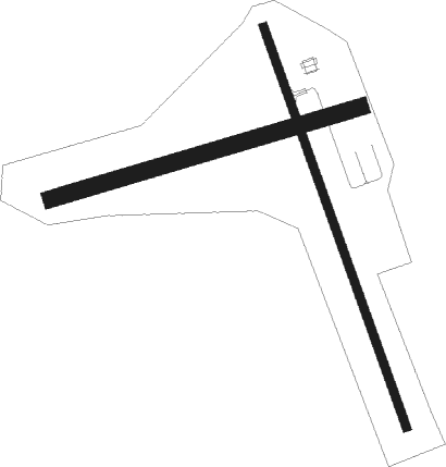
Runway info
Runway 17 / 35  | ||
| length | 1131m (3711ft) | |
| bearing | 159° / 339° | |
| width | 23m (75ft) | |
| surface | asphalt | |
| displ threshold | 58m (190ft) / 172m (564ft) | |
| Runway 08 / 26 | ||
| length | 859m (2818ft) | |
| bearing | 82° / 262° | |
| width | 46m (150ft) | |
| surface | grass | |
| displ threshold | 117m (384ft) / 118m (387ft) | |
Nearby beacons
| code | identifier | dist | bearing | frequency |
|---|---|---|---|---|
| HYR | DME | 13.4 | 228° | 113.40 |
| RCX | RUSK COUNTY (LADYSMITH) NDB | 42.9 | 160° | 356 |
| DLH | DULUTH VORTAC | 53.7 | 302° | 112.60 |
| LKI | LAKESIDE (DULUTH) TACAN | 54.9 | 305° | 135.40 |
| RP | WICKR (RICE LAKE) NDB | 57.5 | 212° | 221 |
Instrument approach procedures
| runway | airway (heading) | route (dist, bearing) |
|---|---|---|
| RW35 | CYETT (338°) | CYETT 3200ft |
| RW35 | GRASS (220°) | GRASS POYSI (18mi, 164°) 3200ft CYETT (6mi, 259°) 3200ft |
| RW35 | QESCA (39°) | QESCA ONAVE (30mi, 45°) 3200ft CYETT (6mi, 79°) 3200ft |
| RNAV | CYETT 3200ft ARAFE (4mi, 339°) 3200ft 3CU (6mi, 338°) 1407ft (5457mi, 117°) 3200ft CYETT (5454mi, 297°) 3200ft CYETT (turn) |
Disclaimer
The information on this website is not for real aviation. Use this data with the X-Plane flight simulator only! Data taken with kind consent from X-Plane 12 source code and data files. Content is subject to change without notice.