Estherwood - Le Gros Memorial
Airport details
| Country | United States of America |
| State | Louisiana |
| Region | K4 |
| Municipality | Acadia Parish |
| Elevation | 14ft (4m) |
| Timezone | GMT -6 |
| Coordinates | 30.16178, -92.48397 |
| Magnetic var | |
| Type | land |
| Available since | X-Plane v10.40 |
| ICAO code | 3R2 |
| IATA code | n/a |
| FAA code | 3R2 |
Communication
| Le Gros Memorial CTAF | 122.900 |
Nearby Points of Interest:
Istre Cemetery Grave Houses
-Bank of Gueydan
-Jennings Carnegie Public Library
-Joseph D. Bernard House
-Dr. Joseph Angel Villien House
-Le Vieux Presbytere
-St. Mary Congregational Church
-Elton United Methodist Church
-Chretien Point Plantation
-Old Lafayette City Hall
-Brandt House (Lafayette, Louisiana)
-Freetown-Port Rico Historic District
-Joseph Jefferson House
-Edward Benjamin Dubuisson House
-Allen Parish Courthouse
-Alexis LaTour House
-Evangeline Bank and Trust Company
-St. Martin Parish Courthouse
-Fontenette-Bienvenu House
-Longfellow-Evangeline State Historic Site
-Maison Olivier
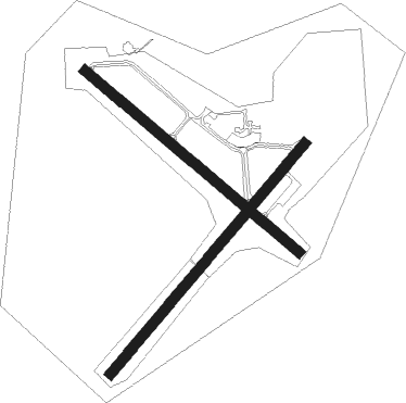
Runway info
Runway 4 / 22  | ||
| length | 1313m (4308ft) | |
| bearing | 49° / 229° | |
| width | 46m (150ft) | |
| surface | concrete | |
| Runway 13 / 31 | ||
| length | 1221m (4006ft) | |
| bearing | 131° / 311° | |
| width | 46m (150ft) | |
| surface | concrete | |
| displ threshold | 73m (240ft) / 0m (0ft) | |
Nearby beacons
| code | identifier | dist | bearing | frequency |
|---|---|---|---|---|
| BNZ | ABBEVILLE NDB | 19.6 | 106° | 230 |
| ECY | DURALDE (EUNICE) NDB | 23.9 | 5° | 263 |
| LFT | LAFAYETTE VORTAC | 25.5 | 86° | 109.80 |
| LLA | WHITE LAKE VOR/DME | 30.4 | 168° | 110.40 |
| LF | LAFFS (LAFARETTE) NDB | 30.8 | 78° | 375 |
| LCH | LAKE CHARLES VORTAC | 32.3 | 268° | 113.40 |
| CW | MOSSY (LAKE CHARLES) NDB | 37.9 | 281° | 418 |
| AUR | SULFY (SULPHUR) NDB | 48.6 | 272° | 278 |
| DXB | DE RIDDER NDB | 56.5 | 305° | 385 |
| FXU | POLK (FORT POLK) VOR | 68.5 | 322° | 108.40 |
Disclaimer
The information on this website is not for real aviation. Use this data with the X-Plane flight simulator only! Data taken with kind consent from X-Plane 12 source code and data files. Content is subject to change without notice.