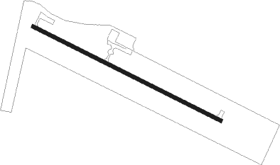
Many - Hart
Airport details
| Country | United States of America |
| State | Louisiana |
| Region | K4 |
| Airspace | Houston Oceanic Ctr |
| Municipality | Sabine Parish |
| Elevation | 324ft (99m) |
| Timezone | GMT -6 |
| Coordinates | 31.54450, -93.48597 |
| Magnetic var | |
| Type | land |
| Available since | X-Plane v10.40 |
| ICAO code | 3R4 |
| IATA code | n/a |
| FAA code | n/a |
Communication
| Hart CTAF/UNICOM | 122.800 |
| Hart POLK Approach/Departure | 123.700 |
Nearby Points of Interest:
Fort Jesup
-Kansas City Southern Depot, Zwolle
-Hodges Gardens State Park
-Gaines–Oliphint House
-Normal Hill Historic District
-Natchitoches Historic District
-Cherokee Plantation
-Oaklawn Plantation (Natchez, Louisiana)
-Narcisse Prudhomme Plantation
-Oakland Plantation
-First United Methodist Church
-Vernon Parish Courthouse
-Edmond Ellison Smart House
-Melrose Plantation
-Jones House
-Kate Chopin House
-DeSoto Parish Courthouse
-San Augustine County Courthouse and Jail
Runway info
| Runway 12 / 30 | ||
| length | 1343m (4406ft) | |
| bearing | 117° / 297° | |
| width | 23m (75ft) | |
| surface | asphalt | |
Nearby beacons
| code | identifier | dist | bearing | frequency |
|---|---|---|---|---|
| OOC | NATCHITOCHES NDB | 21.9 | 75° | 407 |
| FXU | POLK (FORT POLK) VOR | 29.3 | 148° | 108.40 |
| CZJ | AMASON (CENTER) NDB | 38.2 | 293° | 341 |
| DXB | DE RIDDER NDB | 48.2 | 169° | 385 |
| SWB | SAWMILL (WINNFIELD) VOR/DME | 48.6 | 62° | 113.75 |
| EMG | ELM GROVE VORTAC | 51.7 | 353° | 111.20 |
| AEX | ALEXANDRIA VORTAC | 53.3 | 106° | 116.10 |
| RPF | CARTHAGE NDB | 56.2 | 308° | 332 |
| BAD | BARKSDALE (BOSSIER CITY) TACAN | 58.3 | 349° | 115.80 |
Instrument approach procedures
| runway | airway (heading) | route (dist, bearing) |
|---|---|---|
| RW12 | COVEX (145°) | COVEX RIKKS (12mi, 145°) 3000ft HEKET (6mi, 215°) 2500ft |
| RW12 | MARTA (171°) | MARTA RIKKS (6mi, 235°) 3000ft HEKET (6mi, 215°) 2500ft |
| RNAV | HEKET 2500ft TILRR (6mi, 117°) 2000ft 3R4 (5mi, 118°) 368ft NOKSY (4mi, 117°) SOMCA (7mi, 35°) MARTA (15mi, 318°) 4500ft MARTA (turn) | |
| RW30 | MARTA (171°) | MARTA TOBOC (20mi, 126°) 3000ft OXIDE (6mi, 199°) 2500ft |
| RW30 | NUBOY (274°) | NUBOY OXIDE (14mi, 265°) 2500ft |
| RNAV | OXIDE 2500ft JATOV (6mi, 284°) 2400ft KENCY (3mi, 284°) 1260ft MOFCO (2mi, 284°) 543ft PEXTU (4mi, 284°) MARTA (14mi, 7°) 4500ft MARTA (turn) |
Disclaimer
The information on this website is not for real aviation. Use this data with the X-Plane flight simulator only! Data taken with kind consent from X-Plane 12 source code and data files. Content is subject to change without notice.
