Jennings
Airport details
| Country | United States of America |
| State | Louisiana |
| Region | K4 |
| Municipality | Jennings |
| Elevation | 21ft (6m) |
| Timezone | GMT -6 |
| Coordinates | 30.24270, -92.67350 |
| Magnetic var | |
| Type | land |
| Available since | X-Plane v10.40 |
| ICAO code | 3R7 |
| IATA code | n/a |
| FAA code | n/a |
Communication
| Jennings CTAF/UNICOM | 122.800 |
| Jennings LAKE CHARLES Approach/Departure | 119.800 |
Nearby Points of Interest:
Jennings Carnegie Public Library
-Istre Cemetery Grave Houses
-Elton United Methodist Church
-Bank of Gueydan
-Joseph D. Bernard House
-Allen Parish Courthouse
-Le Vieux Presbytere
-Muller's Department Store
-Dr. Joseph Angel Villien House
-Chretien Point Plantation
-St. Mary Congregational Church
-Evangeline Bank and Trust Company
-Alexis LaTour House
-Old Lafayette City Hall
-Brandt House (Lafayette, Louisiana)
-Freetown-Port Rico Historic District
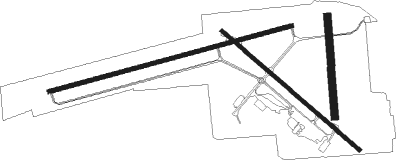
Runway info
Runway 8 / 26  | ||
| length | 1522m (4993ft) | |
| bearing | 81° / 261° | |
| width | 23m (75ft) | |
| surface | asphalt | |
| Runway 13 / 31 | ||
| length | 1099m (3606ft) | |
| bearing | 131° / 311° | |
| width | 23m (75ft) | |
| surface | asphalt | |
| displ threshold | 0m (0ft) / 183m (600ft) | |
| Runway 17 / 35 | ||
| length | 603m (1978ft) | |
| bearing | 180° / 0° | |
| width | 46m (150ft) | |
| surface | grass | |
Nearby beacons
| code | identifier | dist | bearing | frequency |
|---|---|---|---|---|
| ECY | DURALDE (EUNICE) NDB | 22.3 | 35° | 263 |
| LCH | LAKE CHARLES VORTAC | 23.2 | 257° | 113.40 |
| CW | MOSSY (LAKE CHARLES) NDB | 27.3 | 277° | 418 |
| BNZ | ABBEVILLE NDB | 30.5 | 108° | 230 |
| LFT | LAFAYETTE VORTAC | 35.4 | 94° | 109.80 |
| LLA | WHITE LAKE VOR/DME | 38.1 | 153° | 110.40 |
| AUR | SULFY (SULPHUR) NDB | 38.8 | 267° | 278 |
| LF | LAFFS (LAFARETTE) NDB | 39.8 | 87° | 375 |
| DXB | DE RIDDER NDB | 45.9 | 308° | 385 |
| FXU | POLK (FORT POLK) VOR | 59.3 | 328° | 108.40 |
Instrument approach procedures
| runway | airway (heading) | route (dist, bearing) |
|---|---|---|
| RW08 | CEGUV (81°) | CEGUV 3000ft |
| RNAV | CEGUV 3000ft HALRU (6mi, 81°) 1700ft WEBAK (3mi, 81°) 720ft 3R7 (3mi, 83°) 67ft (5544mi, 108°) 400ft CEGUV (5556mi, 288°) 3000ft CEGUV (turn) | |
| RW26 | TUYOD (260°) | TUYOD 3000ft |
| RNAV | TUYOD 3000ft MALMS (6mi, 261°) 1700ft WADBO (4mi, 261°) 580ft 3R7 (2mi, 258°) 70ft (5544mi, 108°) 290ft CEGUV (5556mi, 288°) 3000ft CEGUV (turn) |
Disclaimer
The information on this website is not for real aviation. Use this data with the X-Plane flight simulator only! Data taken with kind consent from X-Plane 12 source code and data files. Content is subject to change without notice.