Manzanita - Nehalem Bay State
Airport details
| Country | United States of America |
| State | Oregon |
| Region | |
| Airspace | Seattle Ctr |
| Municipality | Tillamook County |
| Elevation | 20ft (6m) |
| Timezone | GMT -8 |
| Coordinates | 45.70126, -123.93007 |
| Magnetic var | |
| Type | land |
| Available since | X-Plane v10.40 |
| ICAO code | 3S7 |
| IATA code | n/a |
| FAA code | 3S7 |
Communication
Nearby Points of Interest:
Mary Frances Isom Cottage
-A. E. Doyle Cottage
-Harry F. Wentz Studio
-Daniel Knight Warren House
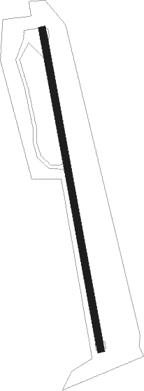
Runway info
| Runway 15 / 33 | ||
| length | 717m (2352ft) | |
| bearing | 172° / 352° | |
| width | 15m (50ft) | |
| surface | asphalt | |
Nearby beacons
| code | identifier | dist | bearing | frequency |
|---|---|---|---|---|
| AST | ASTORIA VOR/DME | 27.7 | 6° | 114 |
| PND | BANKS (PORTLAND) NDB | 37.3 | 95° | 356 |
| UBG | NEWBERG VOR/DME | 45.1 | 110° | 117.40 |
| SL | TURNO (SALEM) NDB | 65.8 | 131° | 266 |
Disclaimer
The information on this website is not for real aviation. Use this data with the X-Plane flight simulator only! Data taken with kind consent from X-Plane 12 source code and data files. Content is subject to change without notice.