Versailles - Roy Otten Memorial
Airport details
| Country | United States of America |
| State | Missouri |
| Region | |
| Airspace | Kansas City Ctr |
| Municipality | Morgan County |
| Elevation | 1028ft (313m) |
| Timezone | GMT -6 |
| Coordinates | 38.42858, -92.87136 |
| Magnetic var | |
| Type | land |
| Available since | X-Plane v10.40 |
| ICAO code | 3VS |
| IATA code | VRS |
| FAA code | 3VS |
Communication
Nearby Points of Interest:
Morgan County Courthouse
-Finke Opera House
-Moniteau County Courthouse Square
-Gray-Wood Buildings
-Prairie View
-McVey School
-Missouri, Kansas and Texas Railroad Depot
-Ravenswood
-Missouri/Sedalia Trust Company
-Sedalia Public Library
-Harris House
-Building at 217 West Main Street
-William H. Gentry House
-Upper Bridge
-Joseph and Elizabeth Wallendorf House
-Samuel E. Hackman Building
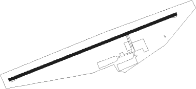
Runway info
| Runway 7 / 25 | ||
| length | 856m (2808ft) | |
| bearing | 76° / 256° | |
| width | 12m (39ft) | |
| surface | asphalt | |
Nearby beacons
| code | identifier | dist | bearing | frequency |
|---|---|---|---|---|
| SHY | SUNSHINE (KAISER) VOR/DME | 26.5 | 145° | 108.40 |
| SZL | WHITEMAN (KNOB NOSTER) TACAN | 36.8 | 294° | 109.80 |
| COU | COLUMBIA VOR/DME | 38.2 | 60° | 110.20 |
| JE | ALGOA (JEFFERSON CITY) NDB | 38.2 | 82° | 397 |
| HLV | HALLSVILLE VORTAC | 53.8 | 47° | 114.20 |
| TBN | FORNEY (FORT LEONARD WOOD VOR | 53.8 | 133° | 110 |
| BHN | BUCKHORN (FORT LEONARD WOOD) NDB | 56.9 | 134° | 391 |
Disclaimer
The information on this website is not for real aviation. Use this data with the X-Plane flight simulator only! Data taken with kind consent from X-Plane 12 source code and data files. Content is subject to change without notice.