Mountain Green - Morgan County
Airport details
| Country | United States of America |
| State | Utah |
| Region | K2 |
| Airspace | Salt Lake City Ctr |
| Municipality | Morgan County |
| Elevation | 5020ft (1530m) |
| Timezone | GMT -7 |
| Coordinates | 41.14867, -111.76715 |
| Magnetic var | |
| Type | land |
| Available since | X-Plane v10.40 |
| ICAO code | 42U |
| IATA code | n/a |
| FAA code | 42U |
Communication
| Morgan County CTAF/UNICOM | 122.800 |
Nearby Points of Interest:
Devil's Gate-Weber Hydroelectric Power Plant
-Morgan High School Mechanical Arts Building
-Morgan Union Pacific Depot
-Gustav Becker House
-Avon Apartments
-Joseph Adams House (Layton, Utah)
-El Monte Golf Course Clubhouse
-McGregor Apartments
-Fontenelle Apartments
-Heber Scowcroft House
-Hillcrest Apartments
-Flowers Apartments
-Arvondor Apartments
-Andrew J. Warner House
-Ladywood Apartments
-Madison Elementary School
-Dennis A. Smyth House
-John Moses Browning House
-Farnsworth Apartments
-La Frantz Apartments
-Avelan Apartments
-Upton Apartments
-Fern-Marylyn Apartments
-United States Forest Service Building
-Jefferson Avenue Historic District
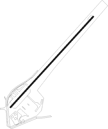
Runway info
| Runway 3 / 21 | ||
| length | 1188m (3898ft) | |
| bearing | 55° / 235° | |
| width | 15m (50ft) | |
| surface | asphalt | |
| displ threshold | 65m (213ft) / 65m (213ft) | |
Nearby beacons
| code | identifier | dist | bearing | frequency |
|---|---|---|---|---|
| HIF | HILL (OGDEN) TACAN | 9 | 262° | 111.20 |
| OGD | OGDEN VORTAC | 15.6 | 283° | 115.70 |
| TCH | WASATCH VORTAC | 20.3 | 216° | 116.80 |
| EVW | EVANSTON VOR/DME | 33.3 | 80° | 109.60 |
| LHO | BRIGHAM CITY (LOGAN) VOR/DME | 40.2 | 339° | 112.90 |
| FFU | FAIRFIELD (PROVO) VORTAC | 53 | 191° | 116.60 |
| PVU | PROVO VOR/DME | 56.1 | 177° | 108.40 |
Disclaimer
The information on this website is not for real aviation. Use this data with the X-Plane flight simulator only! Data taken with kind consent from X-Plane 12 source code and data files. Content is subject to change without notice.