Cedartown - Polk County
Airport details
| Country | United States of America |
| State | Georgia |
| Region | K7 |
| Airspace | Atlanta Ctr |
| Municipality | Polk County |
| Elevation | 974ft (297m) |
| Timezone | GMT -5 |
| Coordinates | 34.01870, -85.14647 |
| Magnetic var | |
| Type | land |
| Available since | X-Plane v10.40 |
| ICAO code | 4A4 |
| IATA code | n/a |
| FAA code | n/a |
Communication
| Polk County CTAF/UNICOM | 122.800 |
Nearby Points of Interest:
Hawkes Children's Library
-Cedartown Waterworks-Woman's Building-Big Spring Park Historic District
-Haralson County Courthouse
-Between the Rivers Historic District
-Marshall Forest
-United States Post Office and Courthouse
-Paulding County Courthouse
-Etowah Indian Mounds
-Roselawn Museum
-Bartow County Courthouse
-Pickett's Mill Battlefield Site
-Old Bartow County Courthouse
-Cassville Post Office
-North Villa Rica Commercial Historic District
-Hiram Colored School
-Southern Railway Depot
-Douglas County Courthouse
-Col. William T. Roberts House
-Carroll County Courthouse
-William Gibbs McAdoo House
-Corra White Harris House, Study, and Chapel
-Dr. James L. Lovvorn House
-Calhoun Depot
-Beulah Grove Lodge No. 372, Free and Accepted York Masons
-Robert Mable House and Cemetery
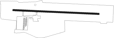
Runway info
| Runway 10 / 28 | ||
| length | 1222m (4009ft) | |
| bearing | 96° / 276° | |
| width | 23m (75ft) | |
| surface | asphalt | |
Nearby beacons
| code | identifier | dist | bearing | frequency |
|---|---|---|---|---|
| RMG | ROME VORTAC | 8.7 | 11° | 115.40 |
| GPQ | CARROLLTON NDB | 27.2 | 178° | 278 |
| DOB | DOBBINS (MARIETTA) TACAN | 32.4 | 99° | 113 |
| DJD | CHERO NDB | 35.6 | 70° | 415 |
| AT | CATTA (ATLANTA) NDB | 37.5 | 122° | 375 |
| ATL | ATLANTA VORTAC | 42.5 | 119° | 116.90 |
| PDK | PEACHTREE (ATLANTA) VOR/DME | 43 | 100° | 116.60 |
| GAD | GADSDEN VOR/DME | 46.7 | 267° | 112.30 |
| AN | BOGGA (ANNISTON) NDB | 48.7 | 238° | 211 |
| EQQ | COWETA COUNTY (NEWNAN) NDB | 50.6 | 150° | 234 |
| TDG | DME | 52 | 244° | 108.80 |
| FFC | PECAT (ATLANTA) NDB | 54.2 | 137° | 316 |
| GQO | CHOO CHOO (CHATTANOOGA) VORTAC | 56.6 | 360° | 115.80 |
| LGC | LA GRANGE VORTAC | 58.3 | 184° | 115.60 |
Instrument approach procedures
| runway | airway (heading) | route (dist, bearing) |
|---|---|---|
| RW10 | MAFLY (96°) | MAFLY 3700ft |
| RNAV | MAFLY 3700ft ANTIY (7mi, 96°) 2700ft JEKAG (3mi, 96°) 1600ft 4A4 (2mi, 96°) 1012ft (5164mi, 112°) 1600ft MAFLY (5176mi, 292°) 3700ft MAFLY (turn) | |
| RW28 | GUSSY (276°) | GUSSY 3100ft |
| RNAV | GUSSY 3100ft ANTOW (7mi, 276°) 2600ft ZIRIX (3mi, 276°) 1740ft 4A4 (3mi, 276°) 995ft (5164mi, 112°) 1500ft GUSSY (5152mi, 292°) 3100ft GUSSY (turn) |
Disclaimer
The information on this website is not for real aviation. Use this data with the X-Plane flight simulator only! Data taken with kind consent from X-Plane 12 source code and data files. Content is subject to change without notice.