Willcox - Leroy
Airport details
| Country | United States of America |
| State | Arizona |
| Region | |
| Airspace | Albuquerque Ctr |
| Municipality | Cochise County |
| Elevation | 4195ft (1279m) |
| Timezone | GMT -7 |
| Coordinates | 32.11320, -109.76101 |
| Magnetic var | |
| Type | land |
| Available since | X-Plane v10.40 |
| ICAO code | 4AZ9 |
| IATA code | n/a |
| FAA code | 4AZ9 |
Communication
Nearby Points of Interest:
Willcox Playa
-Willcox Women's Club
-J.H. Smith Grocery Store and Filling Station
-Faraway Ranch Historic District
-Chiricahua National Monument Historic Designed Landscape
-Sierra Bonita Ranch
-Sacred Heart Church
-Tombstone Historic District
-Tombstone Courthouse State Historic Park
-Portal Ranger Station
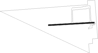
Runway info
| Runway 07 / 25 | ||
| length | 753m (2470ft) | |
| bearing | 91° / 271° | |
| width | 21m (70ft) | |
| surface | dirt | |
Nearby beacons
| code | identifier | dist | bearing | frequency |
|---|---|---|---|---|
| SSO | SAN SIMON VORTAC | 26.9 | 73° | 115.40 |
| DUG | DOUGLAS VORTAC | 39.3 | 166° | 108.80 |
| ARH | FORT HUACHUCA TACAN | 43.2 | 228° | 111.60 |
| FHU | LIBBY (FT HUACHUCA) VOR/DME | 43.6 | 229° | 113.60 |
Disclaimer
The information on this website is not for real aviation. Use this data with the X-Plane flight simulator only! Data taken with kind consent from X-Plane 12 source code and data files. Content is subject to change without notice.