Walsenburg - Spanish Peaks
Airport details
| Country | United States of America |
| State | Colorado |
| Region | K2 |
| Airspace | Denver Ctr |
| Municipality | Huerfano County |
| Elevation | 6048ft (1843m) |
| Timezone | GMT -7 |
| Coordinates | 37.69651, -104.78478 |
| Magnetic var | |
| Type | land |
| Available since | X-Plane v10.40 |
| ICAO code | 4V1 |
| IATA code | n/a |
| FAA code | n/a |
Communication
| Spanish Peaks CTAF/UNICOM | 122.800 |
Nearby Points of Interest:
Huerfano County High School
-North Cheyenne Cañon Park
-Montoya Ranch
-Francisco Plaza
-La Veta Pass Narrow Gauge Railroad Depot
-Pueblo Mountain Park
-Ludlow Tent Colony Site
-Monument Lake Park Building and Hatchery Complex
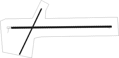
Runway info
Runway 9 / 27  | ||
| length | 1370m (4495ft) | |
| bearing | 93° / 273° | |
| width | 23m (75ft) | |
| surface | asphalt | |
| Runway 02 / 20 | ||
| length | 694m (2277ft) | |
| bearing | 36° / 216° | |
| width | 12m (40ft) | |
| surface | dirt | |
Nearby beacons
| code | identifier | dist | bearing | frequency |
|---|---|---|---|---|
| PUB | PUEBLO VORTAC | 39.6 | 31° | 116.70 |
| TF | ARUBA (PUEBLO) NDB | 41 | 36° | 373 |
| IHS | IRONHORSE (FORT CARSON) NDB | 58.9 | 2° | 335 |
| FCS | BUTTS (FORT CARSON) VOR/DME | 59.1 | 2° | 108.80 |
| CO | PETEY (COLORADO SPRINGS) NDB | 60 | 4° | 407 |
Instrument approach procedures
| runway | airway (heading) | route (dist, bearing) |
|---|---|---|
| RW09 | BLOKE (69°) | BLOKE HUVRA (17mi, 86°) 13500ft ZODLU (8mi, 75°) 12800ft BEIER (12mi, 346°) 10200ft |
| RW09 | GOSIP (292°) | GOSIP HIXIK (10mi, 240°) 11700ft ZODLU (10mi, 261°) 11700ft BEIER (12mi, 346°) 10200ft |
| RW09 | JOGEL (298°) | JOGEL ZODLU (30mi, 272°) 11700ft BEIER (12mi, 346°) 10200ft |
| RNAV | BEIER 10200ft WUBGI (6mi, 81°) 8500ft ZORUM (3mi, 93°) 7360ft 4V1 (4mi, 93°) 6102ft (6105mi, 110°) 6900ft JUKEX (6077mi, 290°) 9400ft JUKEX (turn) | |
| RW27 | BLOKE (69°) | BLOKE ZODLU (25mi, 83°) 13000ft OMPOE (26mi, 66°) 13000ft OMPOE (turn) 8700ft |
| RW27 | JOGEL (298°) | JOGEL OMPOE (16mi, 324°) 8700ft |
| RW27 | RADIO (271°) | RADIO OMPOE (7mi, 270°) 8700ft |
| RW27 | VIGIL (228°) | VIGIL OMPOE (15mi, 181°) 8700ft |
| RNAV | OMPOE 8700ft ZULVO (7mi, 270°) 7600ft 4V1 (5mi, 273°) 6064ft (6105mi, 110°) 6800ft JUKEX (6077mi, 290°) 9400ft JUKEX (turn) |
Disclaimer
The information on this website is not for real aviation. Use this data with the X-Plane flight simulator only! Data taken with kind consent from X-Plane 12 source code and data files. Content is subject to change without notice.