Northwood - Northwood Muni-vince Field
Airport details
| Country | United States of America |
| State | North Dakota |
| Region | K3 |
| Airspace | Minneapolis Ctr |
| Municipality | Grand Forks County |
| Elevation | 1119ft (341m) |
| Timezone | GMT -6 |
| Coordinates | 47.72489, -97.58981 |
| Magnetic var | |
| Type | land |
| Available since | X-Plane v10.40 |
| ICAO code | 4V4 |
| IATA code | n/a |
| FAA code | n/a |
Communication
| Northwood Muni-Vince Field CTAF/UNICOM | 122.800 |
| Northwood Muni-Vince Field GRAND FORKS | 118.100 |
Nearby Points of Interest:
Carl Ben Eielson House
-Avalon Theatre
-Larimore City Hall
-Steele County Courthouse
-Mayville Public Library
-Col. William H. Robinson House
-Stomner House
-Union Block
-Lura Building
-Goose River Bank
-Great Northern Railway Depot
-First State Bank of Buxton
-Oxford House
-University of North Dakota Historic District
-Baldwin's Arcade
-Thomas D. Campbell House
-South Junior High School
-North Dakota Mill and Elevator
-The Kegs Drive-In
-B'nai Israel Synagogue and Montefiore Cemetery
-St. Michael's Church
-Washington School
-Skarsbo Apartments
-Joseph Bell DeRemer House
-United Lutheran Church
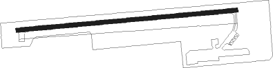
Runway info
| Runway 8 / 26 | ||
| length | 964m (3163ft) | |
| bearing | 90° / 270° | |
| width | 18m (60ft) | |
| surface | asphalt | |
Nearby beacons
| code | identifier | dist | bearing | frequency |
|---|---|---|---|---|
| RDR | RED RIVER (GRAND FORKS) TACAN | 15.7 | 38° | 116.40 |
| GF | HISER NDB | 18 | 73° | 345 |
| GFK | GRAND FORKS VOR/DME | 21.3 | 60° | 114.30 |
| AA | KENIE (FARGO) NDB | 53.3 | 133° | 365 |
| FAR | FARGO VOR/DME | 65.6 | 143° | 116.20 |
Instrument approach procedures
| runway | airway (heading) | route (dist, bearing) |
|---|---|---|
| RW26 | GFK (240°) | GFK CAGOS (10mi, 222°) 3000ft BORPE (5mi, 179°) 3000ft |
| RW26 | JOCOR (281°) | JOCOR DAKME (9mi, 274°) 3000ft BORPE (5mi, 359°) 3000ft |
| RNAV | BORPE 3000ft FARBA (6mi, 270°) 2700ft 4V4 (5mi, 270°) 1158ft (5711mi, 116°) 1800ft UNIZY (5721mi, 296°) 3500ft UNIZY (turn) |
Disclaimer
The information on this website is not for real aviation. Use this data with the X-Plane flight simulator only! Data taken with kind consent from X-Plane 12 source code and data files. Content is subject to change without notice.