East Troy - East Troy Muni
Airport details
| Country | United States of America |
| State | Wisconsin |
| Region | K5 |
| Airspace | Chicago Ctr |
| Municipality | East Troy |
| Elevation | 858ft (262m) |
| Timezone | GMT -6 |
| Coordinates | 42.79716, -88.37261 |
| Magnetic var | |
| Type | land |
| Available since | X-Plane v10.40 |
| ICAO code | 57C |
| IATA code | n/a |
| FAA code | n/a |
Communication
| East Troy Muni AWOS | 118.125 |
| East Troy Muni CTAF/UNICOM | 123.000 |
| East Troy Muni MILWAUKEE Approach/Departure | 125.350 |
Nearby Points of Interest:
Sheboygan Light, Power and Railway Company Car #26
-United Unitarian and Universalist Church
-Franklyn Hazelo House
-John and Margaret Bell House
-Burlington Community Swimming Pools and Bathhouse
-Haseltine Cobblestone House
-Reformed Presbyterian Church of Vernon
-Ten Chimneys
-Elkhorn Municipal Building
-Reynolds-Weed House
-Edward Elderkin House
-W. Ben Hunt Cabin
-Horticultural Hall
-Main Street Historic District
-The Riviera
-Redwood Cottage
-Freewill Baptist Church
-Meyerhofer Cobblestone House
-Robert O. Jones House
-Chicago and North Western Depot
-Arlington Apartments
-Camillia Smith House
-McCall Street Historic District
-St. Joseph's Catholic Church Complex
-First Baptist Church
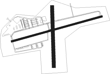
Runway info
Runway 8 / 26  | ||
| length | 1186m (3891ft) | |
| bearing | 82° / 262° | |
| width | 23m (75ft) | |
| surface | asphalt | |
| Runway 18 / 36 | ||
| length | 747m (2451ft) | |
| bearing | 184° / 4° | |
| width | 46m (150ft) | |
| surface | grass | |
Nearby beacons
| code | identifier | dist | bearing | frequency |
|---|---|---|---|---|
| BUU | (BURLINGTON) DME | 7.1 | 147° | 114.50 |
| BAE | BADGER (MILWAUKEE) VOR/DME | 19.5 | 15° | 116.40 |
| RA | PASER (RACINE) NDB | 21.9 | 104° | 206 |
| ENW | DME | 22.8 | 114° | 109.20 |
| LJT | (MILWAUKEE) DME | 23.8 | 47° | 115.65 |
| HRK | (RACINE) DME | 24.6 | 94° | 117.70 |
| RYV | ROCK RIVER (WATERTOWN) NDB | 27.4 | 317° | 371 |
| UG | WAUKE (CHICAGO/WAUKEGAN) NDB | 32.2 | 120° | 379 |
| JVL | JANESVILLE VOR/DME | 35.3 | 252° | 114.30 |
| BJB | WEST BEND VOR | 39 | 22° | 109.80 |
| OBK | NORTHBROOK VOR/DME | 39.2 | 144° | 113 |
| UNU | JUNEAU NDB | 40.6 | 332° | 344 |
| MSN | MADISON VORTAC | 47.3 | 290° | 108.60 |
| RFD | DME | 50.1 | 235° | 110.80 |
| GCO | DME | 52.5 | 150° | 108.25 |
| DPA | DUPAGE (CHICAGO) VOR/DME | 54.4 | 179° | 108.40 |
| FAH | (SHEBOYGAN) DME | 62.6 | 28° | 110 |
Departure and arrival routes
| Transition altitude | 18000ft |
| Transition level | 18000ft |
| SID end points | distance | outbound heading | |
|---|---|---|---|
| ALL | |||
| UECKR6 | 64mi | 132° | |
| ACCRA5 | 54mi | 158° | |
Instrument approach procedures
| runway | airway (heading) | route (dist, bearing) |
|---|---|---|
| RW08 | ACIDU (82°) | ACIDU 3000ft |
| RW08 | LOYRI (103°) | LOYRI 3000ft ACIDU (6mi, 165°) 3000ft |
| RW08 | ODJIR (58°) | ODJIR 3000ft ACIDU (6mi, 345°) 3000ft |
| RNAV | ACIDU 3000ft EGADY (6mi, 82°) 2500ft DECER (2mi, 82°) 1700ft 57C (3mi, 82°) 886ft (5333mi, 116°) 2400ft VEENA (5330mi, 296°) 3000ft VEENA (turn) | |
| RW26 | IJELO (262°) | IJELO 3000ft |
| RW26 | UVUCU (283°) | UVUCU 3000ft IJELO (6mi, 346°) 3000ft |
| RW26 | ZOBAV (239°) | ZOBAV 3000ft IJELO (6mi, 166°) 3000ft |
| RNAV | IJELO 3000ft UMTAY (6mi, 262°) 2500ft CIBAD (3mi, 262°) 1400ft 57C (2mi, 262°) 905ft (5333mi, 116°) 1800ft VEENA (5330mi, 296°) 3000ft VEENA (turn) |
Holding patterns
| STAR name | hold at | type | turn | heading* | altitude | leg | speed limit |
|---|---|---|---|---|---|---|---|
| GOPAC2 | LEEDN | VHF | right | 181 (1)° | DME 10.0mi | ICAO rules | |
| GOPAC2 | ZOWRO | VHF | right | 273 (93)° | DME 10.0mi | ICAO rules | |
| *) magnetic outbound (inbound) holding course | |||||||
Disclaimer
The information on this website is not for real aviation. Use this data with the X-Plane flight simulator only! Data taken with kind consent from X-Plane 12 source code and data files. Content is subject to change without notice.