Washburn - Washburn Muni
Airport details
| Country | United States of America |
| State | North Dakota |
| Region | K3 |
| Airspace | Minneapolis Ctr |
| Municipality | McLean County |
| Elevation | 1908ft (582m) |
| Timezone | GMT -6 |
| Coordinates | 47.35117, -101.02589 |
| Magnetic var | |
| Type | land |
| Available since | X-Plane v10.40 |
| ICAO code | 5C8 |
| IATA code | n/a |
| FAA code | 5C8 |
Communication
| Washburn Muni CTAF | 122.900 |
Nearby Points of Interest:
McLean County Courthouse
-Former McLean County Courthouse
-Wilton, North Dakota Soo Line depot
-Sheridan County Courthouse
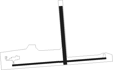
Runway info
Runway 8 / 26  | ||
| length | 1125m (3691ft) | |
| bearing | 90° / 270° | |
| width | 18m (60ft) | |
| surface | concrete | |
| Runway 17 / 35 | ||
| length | 673m (2208ft) | |
| bearing | 180° / 0° | |
| width | 41m (135ft) | |
| surface | grass | |
| displ threshold | 0m (0ft) / 30m (98ft) | |
Nearby beacons
| code | identifier | dist | bearing | frequency |
|---|---|---|---|---|
| HZE | HAZEN NDB | 22.8 | 265° | 414 |
| BIS | BISMARCK VOR/DME | 38.3 | 149° | 116.50 |
| MOT | MINOT VOR/DME | 55.6 | 344° | 117.10 |
Disclaimer
The information on this website is not for real aviation. Use this data with the X-Plane flight simulator only! Data taken with kind consent from X-Plane 12 source code and data files. Content is subject to change without notice.