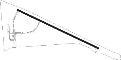
Harvey - Harvey Muni
Airport details
| Country | United States of America |
| State | North Dakota |
| Region | K3 |
| Airspace | Minneapolis Ctr |
| Municipality | Harvey |
| Elevation | 1604ft (489m) |
| Timezone | GMT -6 |
| Coordinates | 47.79122, -99.93175 |
| Magnetic var | |
| Type | land |
| Available since | X-Plane v10.40 |
| ICAO code | 5H4 |
| IATA code | n/a |
| FAA code | n/a |
Communication
| Harvey Muni CTAF/UNICOM | 122.800 |
Nearby Points of Interest:
Vang Evangelical Lutheran Church
-Wells County Courthouse
-Old Mt. Carmel Cemetery, Wrought-Iron Cross Site
-Liberty Baptist Church (Kief, North Dakota)
Instrument approach procedures
| runway | airway (heading) | route (dist, bearing) |
|---|---|---|
| RW11 | IVUVE (132°) | IVUVE 3400ft NUTFO (5mi, 220°) 3400ft |
| RW11 | JISBO (94°) | JISBO 3800ft NUTFO (5mi, 40°) 3400ft |
| RW11 | NUTFO (111°) | NUTFO 3400ft |
| RNAV | NUTFO 3400ft LUGTE (6mi, 111°) 3300ft IPOWU (3mi, 111°) 2340ft 5H4 (2mi, 111°) 1645ft (5805mi, 116°) 1980ft IGIDY (5796mi, 296°) 3300ft IGIDY (turn) | |
| RW29 | HORPU (274°) | HORPU 3400ft IGIDY (5mi, 221°) 3300ft |
| RW29 | IGIDY (291°) | IGIDY 3300ft |
| RW29 | JKALL (314°) | JKALL 3800ft IGIDY (5mi, 41°) 3300ft |
| RNAV | IGIDY 3300ft IPREZ (6mi, 291°) 3100ft 5H4 (5mi, 291°) 1646ft (5805mi, 116°) 2007ft NUTFO (5814mi, 296°) 3400ft NUTFO (turn) |
Disclaimer
The information on this website is not for real aviation. Use this data with the X-Plane flight simulator only! Data taken with kind consent from X-Plane 12 source code and data files. Content is subject to change without notice.
