Prentice
Airport details
| Country | United States of America |
| State | Wisconsin |
| Region | K5 |
| Airspace | Minneapolis Ctr |
| Municipality | Prentice |
| Elevation | 1578ft (481m) |
| Timezone | GMT -6 |
| Coordinates | 45.53842, -90.27931 |
| Magnetic var | |
| Type | land |
| Available since | X-Plane v10.30 |
| ICAO code | 5N2 |
| IATA code | n/a |
| FAA code | n/a |
Communication
| Prentice CTAF | 123.000 |
Nearby Points of Interest:
Fifield Town Hall
-Taylor County Courthouse
-J. W. Benn Building
-Medford Post Office
-Medford Free Public Library
-Jump River Town Hall
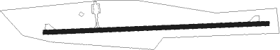
Runway info
| Runway 9 / 27 | ||
| length | 986m (3235ft) | |
| bearing | 92° / 272° | |
| width | 18m (60ft) | |
| surface | asphalt | |
| displ threshold | 102m (335ft) / 32m (105ft) | |
Nearby beacons
| code | identifier | dist | bearing | frequency |
|---|---|---|---|---|
| RH | ARSHA (RHINELANDER) NDB | 28.2 | 82° | 272 |
| DO | DOUGY (MINOCQUA WOODRUFF) NDB | 29.1 | 62° | 236 |
| RCX | RUSK COUNTY (LADYSMITH) NDB | 30.4 | 267° | 356 |
| RHI | RHINELANDER VOR/DME | 35 | 83° | 109.20 |
| AUW | WAUSAU VOR/DME | 50.8 | 135° | 111.60 |
| IWD | IRONWOOD VOR/DME | 60 | 9° | 108.80 |
Disclaimer
The information on this website is not for real aviation. Use this data with the X-Plane flight simulator only! Data taken with kind consent from X-Plane 12 source code and data files. Content is subject to change without notice.