Sedan - Sedan City
Airport details
| Country | United States of America |
| State | Kansas |
| Region | |
| Airspace | Kansas City Ctr |
| Municipality | Chautauqua County |
| Elevation | 1003ft (306m) |
| Timezone | GMT -6 |
| Coordinates | 37.15392, -96.18462 |
| Magnetic var | |
| Type | land |
| Available since | X-Plane v10.40 |
| ICAO code | 61K |
| IATA code | n/a |
| FAA code | 61K |
Communication
Nearby Points of Interest:
Elk Falls Pratt Truss Bridge
-Union Implement and Hardware Building-Masonic Temple
-Booth Theater
-Old Washington County Courthouse
-Onion Creek Bridge (Coffeyville, Kansas)
-LaQuinta
-Esch's Spur Bridge
-City Hall
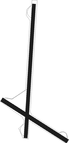
Runway info
Runway 18 / 36  | ||
| length | 964m (3163ft) | |
| bearing | 190° / 10° | |
| width | 25m (81ft) | |
| surface | grass | |
| Runway 12 / 30 | ||
| length | 546m (1791ft) | |
| bearing | 121° / 301° | |
| width | 29m (95ft) | |
| surface | grass | |
Nearby beacons
| code | identifier | dist | bearing | frequency |
|---|---|---|---|---|
| BV | DEWIE (BARTLESVILLE) NDB | 20.5 | 152° | 201 |
| BVO | BARTLESVILLE VOR/DME | 20.7 | 153° | 117.90 |
| CNU | CHANUTE VOR/DME | 40 | 51° | 109.20 |
| OSW | OSWEGO VOR/DME | 46.9 | 90° | 117.60 |
| PN | PONCA (PONCA CITY) NDB | 48.1 | 250° | 515 |
| PER | PIONEER (PONCA CITY) VORTAC | 52.8 | 247° | 113.20 |
| TUL | TULSA VORTAC | 60.6 | 158° | 114.40 |
| SW | BLAKI (STILLWATER) NDB | 70.1 | 225° | 255 |
| SWO | STILLWATER VOR/DME | 70.5 | 224° | 108.40 |
Disclaimer
The information on this website is not for real aviation. Use this data with the X-Plane flight simulator only! Data taken with kind consent from X-Plane 12 source code and data files. Content is subject to change without notice.