Forrest - Curtis And Curtis
Airport details
| Country | United States of America |
| State | New Mexico |
| Region | |
| Airspace | Albuquerque Ctr |
| Municipality | Quay |
| Elevation | 4689ft (1429m) |
| Timezone | GMT -7 |
| Coordinates | 34.72673, -103.60968 |
| Magnetic var | |
| Type | land |
| Available since | X-Plane v10.40 |
| ICAO code | 65E |
| IATA code | n/a |
| FAA code | 65NM |
Communication
Nearby Points of Interest:
Metropolitan Park Bathhouse and Pool Historic District
-Old Clovis Post Office
-Arch Hurley Conservancy District Office Building
-Baca-Goodman House
-Curry County Courthouse
-Clovis Central Fire Station
-Clovis Depot
-1908 Clovis City Hall and Fire Station
-Clovis Baptist Hospital
-Hillcrest Park Archway
-Blackwater Draw archaeological site
-Richardson Store
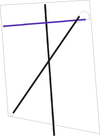
Runway info
Runway 17 / 35  | ||
| length | 1102m (3615ft) | |
| bearing | 181° / 1° | |
| width | 12m (40ft) | |
| surface | dirt | |
| Runway 9 / 27 | ||
| length | 689m (2260ft) | |
| bearing | 90° / 270° | |
| width | 11m (35ft) | |
| surface | dirt | |
| Runway 5 / 23 | ||
| length | 979m (3212ft) | |
| bearing | 45° / 225° | |
| width | 12m (40ft) | |
| surface | dirt | |
Nearby beacons
| code | identifier | dist | bearing | frequency |
|---|---|---|---|---|
| CVS | CANNON (CLOVIS) TACAN | 25.1 | 140° | 111.60 |
| TCC | TUCUMCARI VORTAC | 27.3 | 1° | 113.60 |
| CV | HISAN (CLOVIS) NDB | 31.2 | 131° | 335 |
| TXO | TEXICO VORTAC | 40.5 | 107° | 112.20 |
Disclaimer
The information on this website is not for real aviation. Use this data with the X-Plane flight simulator only! Data taken with kind consent from X-Plane 12 source code and data files. Content is subject to change without notice.