Davenport
Airport details
| Country | United States of America |
| State | Washington |
| Region | K1 |
| Airspace | Seattle Ctr |
| Municipality | Davenport |
| Elevation | 2419ft (737m) |
| Timezone | GMT -8 |
| Coordinates | 47.65355, -118.16879 |
| Magnetic var | |
| Type | land |
| Available since | X-Plane v10.40 |
| ICAO code | 68S |
| IATA code | n/a |
| FAA code | n/a |
Communication
| Davenport CTAF | 122.900 |
Nearby Points of Interest:
Harrington Bank Block & Opera House
-Little Falls Hydroelectric Power Plant
-Spokane River Bridge at Long Lake Dam
-Long Lake Hydroelectric Power Plant
-Cheney Odd Fellows Hall
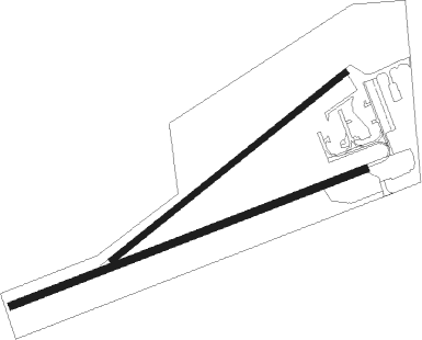
Runway info
Runway 5 / 23  | ||
| length | 838m (2749ft) | |
| bearing | 79° / 259° | |
| width | 15m (50ft) | |
| surface | asphalt | |
| Runway 03 / 21 | ||
| length | 662m (2172ft) | |
| bearing | 65° / 245° | |
| width | 14m (45ft) | |
| surface | gravel | |
Nearby beacons
| code | identifier | dist | bearing | frequency |
|---|---|---|---|---|
| SKA | FAIRCHILD (SPOKANE) TACAN | 20.6 | 95° | 111.40 |
| GEG | SPOKANE VORTAC | 22.5 | 99° | 115.50 |
| DPY | DEER PARK NDB | 35.3 | 67° | 365 |
| PUW | PULLMAN (PULLMAN/MOSCOW) VOR/DME | 70.3 | 136° | 109 |
Disclaimer
The information on this website is not for real aviation. Use this data with the X-Plane flight simulator only! Data taken with kind consent from X-Plane 12 source code and data files. Content is subject to change without notice.