Lisbon - Lisbon Muni
Airport details
| Country | United States of America |
| State | North Dakota |
| Region | K3 |
| Airspace | Minneapolis Ctr |
| Municipality | Island Park Township |
| Elevation | 1240ft (378m) |
| Timezone | GMT -6 |
| Coordinates | 46.44697, -97.72822 |
| Magnetic var | |
| Type | land |
| Available since | X-Plane v10.40 |
| ICAO code | 6L3 |
| IATA code | n/a |
| FAA code | n/a |
Communication
| Lisbon Muni CTAF | 122.900 |
Nearby Points of Interest:
Ransom County Courthouse
-Lisbon Post Office
-Lisbon Bridge (Lisbon, North Dakota)
-T. J. Walker Historic District
-Watts Free Library
-Oakes Post Office
-LaMoure County Courthouse
-Klein and Sutmar Block
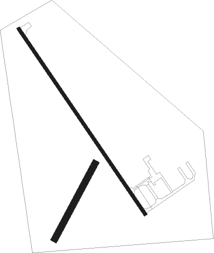
Runway info
Runway 14 / 32  | ||
| length | 1035m (3396ft) | |
| bearing | 140° / 320° | |
| width | 15m (50ft) | |
| surface | asphalt | |
| Runway 03 / 21 | ||
| length | 392m (1286ft) | |
| bearing | 43° / 223° | |
| width | 30m (100ft) | |
| surface | dirt | |
Nearby beacons
| code | identifier | dist | bearing | frequency |
|---|---|---|---|---|
| FAR | FARGO VOR/DME | 40.5 | 71° | 116.20 |
| JMS | JAMESTOWN VOR/DME | 48.8 | 297° | 114.50 |
| AA | KENIE (FARGO) NDB | 50.5 | 58° | 365 |
Instrument approach procedures
| runway | airway (heading) | route (dist, bearing) |
|---|---|---|
| RW14 | WEBOB (140°) | WEBOB 3600ft |
| RNAV | WEBOB 3600ft CAMAG (8mi, 140°) 3000ft WERIR (4mi, 140°) 1840ft 6L3 (2mi, 141°) 1267ft (5724mi, 115°) 1540ft CUKOB (5719mi, 295°) 3600ft CUKOB (turn) | |
| RW32 | CUKOB (320°) | CUKOB 3600ft |
| RNAV | CUKOB 3600ft JETGO (8mi, 320°) 2800ft HAUTE (3mi, 320°) 1960ft 6L3 (2mi, 319°) 1259ft (5724mi, 115°) 1519ft WEBOB (5730mi, 295°) 3600ft WEBOB (turn) |
Disclaimer
The information on this website is not for real aviation. Use this data with the X-Plane flight simulator only! Data taken with kind consent from X-Plane 12 source code and data files. Content is subject to change without notice.