Denver - Little Mountain
Airport details
| Country | United States of America |
| State | North Carolina |
| Region | K7 |
| Airspace | Atlanta Ctr |
| Municipality | Catawba County |
| Elevation | 1027ft (313m) |
| Timezone | GMT -5 |
| Coordinates | 35.59180, -81.07952 |
| Magnetic var | |
| Type | land |
| Available since | X-Plane v10.40 |
| ICAO code | 6NC1 |
| IATA code | n/a |
| FAA code | 6NC1 |
Communication
Nearby Points of Interest:
Balls Creek Campground
-Murray's Mill Historic District
-Ingleside
-Foil–Cline House
-Newton Downtown Historic District
-Grace Reformed Church
-Bost-Burris House
-Johnson-Neel House
-St. Paul's Reformed Church
-Lincoln County Courthouse
-First Baptist Church
-St. Luke's Church and Cemetery
-Emanuel United Church of Christ
-First United Methodist Church
-Lincolnton Recreation Department Youth Center
-Lincolnton Commercial Historic District
-Pleasant Retreat Academy
-Caldwell-Cobb-Love House
-Abraham Anthony Farm
-Shadow Lawn
-South Aspen Street Historic District
-Mount Mourne Plantation
-Andrew Carpenter House
-George Houston House
-Davidson Historic District
Runway info
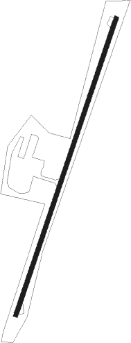
| Runway 3 / 21 | ||
| length | 915m (3002ft) | |
| bearing | 28° / 208° | |
| width | 12m (39ft) | |
| surface | asphalt | |
Nearby beacons
| code | identifier | dist | bearing | frequency |
|---|---|---|---|---|
| HK | TAWBA (HICKORY) NDB | 16 | 311° | 332 |
| BZM | BARRETTS MOUNTAIN (HICKOR VOR/DME | 18.3 | 330° | 113.75 |
| GHJ | STONIA (GASTONIA) NDB | 24.3 | 191° | 260 |
| CLT | CHARLOTTE VOR/DME | 24.9 | 162° | 115 |
| FIQ | FIDDLERS (MORGANTON) NDB | 29.7 | 281° | 391 |
| RU | ROVDY (SALISBURY) NDB | 30 | 77° | 275 |
| SLP | FIRST RIVER (SHELBY) NDB | 32.5 | 237° | 417 |
| UZ | RALLY (ROCK HILL) NDB | 42.1 | 180° | 227 |
| DCM | CHESTER NDB | 48.7 | 189° | 220 |
| VU | ALLER (ALBEMARLE) NDB | 49 | 96° | 346 |
| BAR | HEMLOCK (BANNER ELK) NDB | 51.5 | 305° | 320 |
| JUH | ASHEE (JEFFERSON) NDB | 51.9 | 344° | 410 |
| IN | REENO (WINSTON SALEM) NDB | 52.9 | 62° | 317 |
| LKR | LANCASTER NDB | 53.3 | 166° | 400 |
| SPA | SPARTANBURG VORTAC | 53.3 | 237° | 115.70 |
| UOT | UNION COUNTY NDB | 61.1 | 212° | 326 |
| JJC | MOUNTAIN CITY NDB | 61.3 | 318° | 396 |
| CTF | CHESTERFIELD VOR/DME | 68.9 | 139° | 108.20 |
Disclaimer
The information on this website is not for real aviation. Use this data with the X-Plane flight simulator only! Data taken with kind consent from X-Plane 12 source code and data files. Content is subject to change without notice.