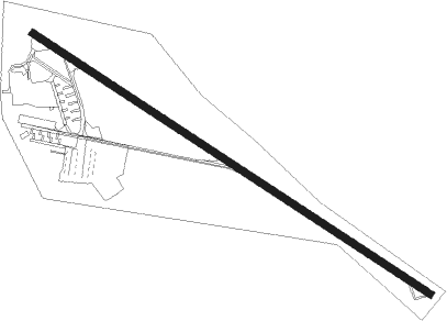
Hadley - Northampton
Airport details
| Country | United States of America |
| State | Massachusetts |
| Region | K6 |
| Airspace | Boston Ctr |
| Municipality | Northampton |
| Elevation | 121ft (37m) |
| Timezone | GMT -5 |
| Coordinates | 42.32801, -72.61124 |
| Magnetic var | |
| Type | land |
| Available since | X-Plane v10.40 |
| ICAO code | 7B2 |
| IATA code | n/a |
| FAA code | n/a |
Communication
| Northampton CTAF/UNICOM | 122.700 |
| Northampton YANKEE Approach/Departure | 125.350 |
Nearby Points of Interest:
Shepherd and Damon Parsons Houses Historic District
-Building at 8–22 Graves Avenue
-The Manse
-Calvin Coolidge House
-Northampton State Hospital
-Hockanum Rural Historic District
-Elm Street Historic District
-Hatfield Center Historic District
-Porter-Phelps-Huntington House
-Mill-Prospect Street Historic District
-Ross Farm
-Northampton Veterans Affairs Medical Center
-Upper Main Street Historic District
-North Hadley Historic District
-Grove Hill Mansion
-Westside Historic District
-Theodore Baird Residence
-United States Post Office–Easthampton Main
-United States Post Office–South Hadley Main
-Bradstreet Historic District
-Lincoln-Sunset Historic District
-The Town Farm
-Prospect-Gaylord Historic District
-North Hatfield Historic District
-Strong House
Runway info
| Runway 14 / 32 | ||
| length | 1016m (3333ft) | |
| bearing | 120° / 300° | |
| width | 15m (50ft) | |
| surface | asphalt | |
| displ threshold | 0m (0ft) / 65m (213ft) | |
Nearby beacons
| code | identifier | dist | bearing | frequency |
|---|---|---|---|---|
| CEF | WESTOVER(SPRINGFIELD/CHIC TACAN | 8.6 | 147° | 114 |
| BAF | BARNES (WESTFIELD/SPRINGF VORTAC | 11 | 212° | 113 |
| CTR | CHESTER VOR/DME | 15.1 | 264° | 115.10 |
| GDM | GARDNER VOR/DME | 27.7 | 68° | 110.60 |
| EEN | DME | 31.3 | 34° | 109.40 |
| PUT | PUTNAM VOR/DME | 40.8 | 116° | 117.40 |
| HFD | HARTFORD VOR/DME | 41.3 | 175° | 114.90 |
| CAM | CAMBRIDGE VOR/DME | 51.4 | 312° | 115 |
| ORW | NORWICH VOR/DME | 53.8 | 142° | 110 |
| PWL | PAWLING (POUGHKEEPSIE) VOR/DME | 55.4 | 241° | 114.30 |
| GON | GROTON VOR/DME | 64.9 | 151° | 110.85 |
| GF | GANSE (GLENS FALLS) NDB | 70.8 | 313° | 209 |
Instrument approach procedures
| runway | airway (heading) | route (dist, bearing) |
|---|---|---|
| RW14 | CTR (84°) | CTR CAAHL (6mi, 18°) 3700ft SMUTZ (5mi, 46°) 3500ft |
| RW14 | WARIC (199°) | WARIC HHEPP (13mi, 249°) 4000ft SMUTZ (5mi, 226°) 3500ft |
| RNAV | SMUTZ 3500ft EXBEB (5mi, 120°) 2700ft CEKLU (3mi, 120°) 1740ft ZALON (2mi, 120°) 1180ft 7B2 (3mi, 120°) 161ft (4639mi, 120°) 521ft GRABB (4637mi, 300°) 3000ft GRABB (turn) |
Disclaimer
The information on this website is not for real aviation. Use this data with the X-Plane flight simulator only! Data taken with kind consent from X-Plane 12 source code and data files. Content is subject to change without notice.
