Las Animas - City Of Las Animas Bent Co
Airport details
| Country | United States of America |
| State | Colorado |
| Region | K2 |
| Airspace | Denver Ctr |
| Municipality | Bent County |
| Elevation | 3915ft (1193m) |
| Timezone | GMT -7 |
| Coordinates | 38.05403, -103.23847 |
| Magnetic var | |
| Type | land |
| Available since | X-Plane v10.40 |
| ICAO code | 7V9 |
| IATA code | n/a |
| FAA code | 7V9 |
Communication
| City of Las Animas Bent Co CTAF | 122.900 |
Nearby Points of Interest:
Bent County High School
-Las Animas Post Office
-Bent County Courthouse and Jail
-Fort Lyon
-North La Junta School
-Dr. Frank Finney House
-Carnegie Public Library
-Hotel Holly–Haswell Hotel
-Prowers County Courthouse
-Santa Fe Railway Manzanola Depot
-Crowley School
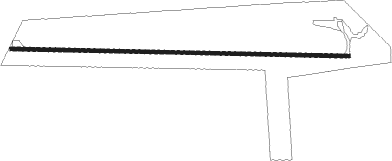
Runway info
| Runway 8 / 26 | ||
| length | 1172m (3845ft) | |
| bearing | 94° / 274° | |
| width | 12m (39ft) | |
| surface | asphalt | |
Nearby beacons
| code | identifier | dist | bearing | frequency |
|---|---|---|---|---|
| LAA | LAMAR VOR/DME | 27.4 | 75° | 116.90 |
| HGO | HUGO VOR/DME | 49.2 | 333° | 112.10 |
| TBE | TOBE VOR/DME | 50.7 | 204° | 114.05 |
Disclaimer
The information on this website is not for real aviation. Use this data with the X-Plane flight simulator only! Data taken with kind consent from X-Plane 12 source code and data files. Content is subject to change without notice.