Briarcliff - Spicewood
Airport details
| Country | United States of America |
| State | Texas |
| Region | K4 |
| Airspace | Houston Oceanic Ctr |
| Municipality | Burnet County |
| Elevation | 830ft (253m) |
| Timezone | GMT -6 |
| Coordinates | 30.47378, -98.12144 |
| Magnetic var | |
| Type | land |
| Available since | X-Plane v10.40 |
| ICAO code | 88R |
| IATA code | n/a |
| FAA code | n/a |
Communication
| Spicewood CTAF/UNICOM | 122.800 |
Nearby Points of Interest:
Levi Rock Shelter
-Horseshoe Bay
-Dr. Joseph M. and Sarah Pound Farmstead
-Dripping Springs
-Longhorn Cavern Administration Building
-Burnet County Courthouse
-Texas Park Road 4
-Lyndon B. Johnson Boyhood Home
-Aynesworth-Wright House
-Austin and Northwestern Railroad Historic District-Fairland to Llano
-Mayfield-Gutsch Estate
-Camp Mabry
-Swedish Hill Historic District
-Shadow Lawn Historic District
-West Line Historic District
-Old West Austin Historic District
-Woodlawn
-Austin State Hospital
-Texas Federation of Women's Clubs Headquarters
-Judge Robert Lynn Batts House
-A. J. Jernigan House
-Ziller House
-Smith-Marcuse-Lowry House
-Granger House and The Perch
-Scottish Rite Dormitory
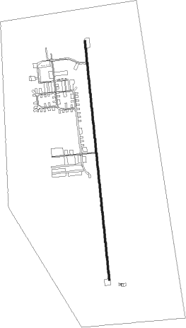
Runway info
| Runway 17 / 35 | ||
| length | 1277m (4190ft) | |
| bearing | 178° / 358° | |
| width | 9m (30ft) | |
| surface | asphalt | |
| displ threshold | 141m (463ft) / 0m (0ft) | |
Nearby beacons
| code | identifier | dist | bearing | frequency |
|---|---|---|---|---|
| CWK | CENTEX VORTAC | 31.1 | 99° | 112.80 |
| RU | GARYS (AUSTIN) NDB | 32.2 | 161° | 272 |
| STV | STONEWALL VORTAC | 34.2 | 245° | 113.80 |
| GRK | GRAY (FORT HOOD) VOR/DME | 37.1 | 29° | 111.80 |
| IL | IRESH (KILLEEN) NDB | 39.3 | 37° | 278 |
| LLO | LLANO VORTAC | 39.4 | 296° | 108.20 |
| AGJ | GOOCH SPRINGS VORTAC | 42.7 | 358° | 112.50 |
| SAT | SAN ANTONIO VORTAC | 52.8 | 202° | 116.80 |
| DHK | RANDOLPH TACAN | 56.7 | 189° | 109.90 |
| TPL | DME | 56.9 | 43° | 110.40 |
| AN | ALAMO (SAN ANTONIO) NDB | 57 | 207° | 368 |
| RND | RANDOLPH VORTAC | 57.9 | 190° | 112.30 |
Disclaimer
The information on this website is not for real aviation. Use this data with the X-Plane flight simulator only! Data taken with kind consent from X-Plane 12 source code and data files. Content is subject to change without notice.