Wilgrove Air Park
Airport details
| Country | United States of America |
| State | North Carolina |
| Region | K7 |
| Airspace | Atlanta Ctr |
| Municipality | Mecklenburg County |
| Elevation | 797ft (243m) |
| Timezone | GMT -5 |
| Coordinates | 35.21376, -80.67007 |
| Magnetic var | |
| Type | land |
| Available since | X-Plane v10.40 |
| ICAO code | 8A6 |
| IATA code | n/a |
| FAA code | n/a |
Communication
| Wilgrove Air Park CTAF | 122.725 |
Nearby Points of Interest:
Neal Somers Alexander House
-Spears House
-Hezekiah Alexander House
-Robert Harvey Morrison Farm and Pioneer Mills Gold Mine
-Rocky River Presbyterian Church
-Matthews Commercial Historic District
-Rosedale
-VanLandingham Estate
-Bishop John C. Kilgo House
-Palmer Fire School
-North Charlotte Historic District
-Victoria
-Highland Park Manufacturing Company Mill No. 3
-James Buchanan Duke House
-Grier-Rea House
-John Price Carr House
-East Avenue Tabernacle Associated Reformed Presbyterian Church
-Seaboard Air Line Railroad Passenger Station
-Mecklenburg County Courthouse
-Commercial Building at 500 North Tryon Street
-Philip Carey Building
-Frederick Apartments
-Liddell-McNinch House
-Grace A.M.E. Zion Church
-Mecklenburg Investment Company Building
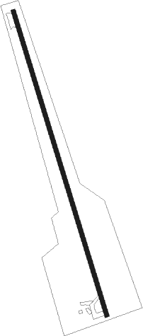
Runway info
| Runway 17 / 35 | ||
| length | 827m (2713ft) | |
| bearing | 165° / 345° | |
| width | 12m (39ft) | |
| surface | asphalt | |
| displ threshold | 30m (98ft) / 60m (197ft) | |
Nearby beacons
| code | identifier | dist | bearing | frequency |
|---|---|---|---|---|
| CLT | CHARLOTTE VOR/DME | 13.8 | 265° | 115 |
| GHJ | STONIA (GASTONIA) NDB | 23.9 | 267° | 260 |
| UZ | RALLY (ROCK HILL) NDB | 28 | 232° | 227 |
| LKR | LANCASTER NDB | 30.9 | 201° | 400 |
| RU | ROVDY (SALISBURY) NDB | 32.4 | 19° | 275 |
| VU | ALLER (ALBEMARLE) NDB | 33.1 | 65° | 346 |
| DCM | CHESTER NDB | 36.6 | 231° | 220 |
| CTF | CHESTERFIELD VOR/DME | 39 | 145° | 108.20 |
| SLP | FIRST RIVER (SHELBY) NDB | 45.6 | 272° | 417 |
| HK | TAWBA (HICKORY) NDB | 46.3 | 312° | 332 |
| BZM | BARRETTS MOUNTAIN (HICKOR VOR/DME | 48.2 | 319° | 113.75 |
| HVS | HARTSVILLE NDB | 55.5 | 146° | 341 |
| IN | REENO (WINSTON SALEM) NDB | 57 | 30° | 317 |
| UOT | UNION COUNTY NDB | 57.4 | 241° | 326 |
| BES | BENNETTSVILLE NDB | 58.3 | 122° | 230 |
| UDG | DARLINGTON NDB | 60.2 | 135° | 245 |
| GSO | GREENSBORO VORTAC | 60.3 | 40° | 116.20 |
| EOE | ENOREE (NEWBERRY) NDB | 72.1 | 227° | 278 |
Disclaimer
The information on this website is not for real aviation. Use this data with the X-Plane flight simulator only! Data taken with kind consent from X-Plane 12 source code and data files. Content is subject to change without notice.