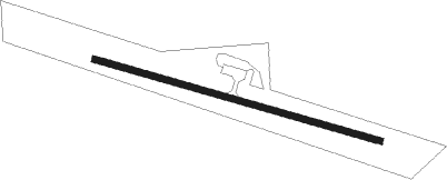
Tipton - Mathews Memorial
Airport details
| Country | United States of America |
| State | Iowa |
| Region | K3 |
| Airspace | Chicago Ctr |
| Municipality | Cedar County |
| Elevation | 837ft (255m) |
| Timezone | GMT -6 |
| Coordinates | 41.76336, -91.15294 |
| Magnetic var | |
| Type | land |
| Available since | X-Plane v10.40 |
| ICAO code | 8C4 |
| IATA code | n/a |
| FAA code | n/a |
Communication
| Mathews Memorial CTAF | 122.900 |
| Mathews Memorial CEDAR RAPIDS Approach/Departure | 119.700 |
Nearby Points of Interest:
Cedar County Sheriff's House and Jail
-Hardacre Theatre
-William Green House
-Mill Creek Bridge
-West Branch Commercial Historic District
-Gruwell and Crew General Store
-Kreinbring Phillips 66 Gas Station
-Henry E. and Ella M. (Knott) Nicolaus House
-Wilton Commercial Historic District
-Wilton Candy Kitchen
-George H. and Loretta Ward House
-Downey Savings Bank
-Downey School
-West Liberty Commercial Historic District
-Muscatine County Fairgrounds
-Muscatine County Home Dairy Barn
-Beers and St. John Company Coach Inn
-Secrest Octagon Barn
-Henyon-Kasper-Duffy Barn
-Elijah D. and Mary J. (Adams) Waln House
-James H. and Mayetta (Degrush) McCartney House
-Adams R., Frederick L. and Martha (Taylor) Knott House
-Roland and Marilyn Wehner House
-Augustus and Elizabeth (Huntsberger) Bauman House
-Col. John Q. and Rowena (Camp) Wilds House
Runway info
| Runway 11 / 29 | ||
| length | 915m (3002ft) | |
| bearing | 106° / 286° | |
| width | 18m (60ft) | |
| surface | concrete | |
Nearby beacons
| code | identifier | dist | bearing | frequency |
|---|---|---|---|---|
| DDD | CITY DME | 23.8 | 179° | 116.50 |
| IOW | IOWA CITY VOR/DME | 25.3 | 242° | 116.20 |
| CID | CEDAR RAPIDS VOR/DME | 29.2 | 281° | 114.10 |
| CVA | DAVENPORT VORTAC | 30.1 | 95° | 113.80 |
| FN | HILLZ (CLINTON) NDB | 34.1 | 91° | 517 |
| MZV | MOLINE VOR/DME | 35.2 | 131° | 114.40 |
| DB | ZILOM (DUBUQUE) NDB | 41.7 | 45° | 341 |
| DBQ | DUBUQUE VORTAC | 43.1 | 35° | 115.80 |
| IIB | WAPSIE (INDEPENDENCE) NDB | 54.5 | 311° | 206 |
| GBG | DME | 59.2 | 139° | 109.80 |
Instrument approach procedures
| runway | airway (heading) | route (dist, bearing) |
|---|---|---|
| RW11 | IOW (62°) | IOW SOLUM (21mi, 33°) 2600ft |
| RW11 | SOLUM (106°) | SOLUM 2600ft |
| RNAV | SOLUM 2600ft TURRU (7mi, 107°) 2600ft 8C4 (6mi, 105°) 880ft (5457mi, 115°) 1240ft GIZCY (5457mi, 295°) 3300ft GIZCY (turn) |
Disclaimer
The information on this website is not for real aviation. Use this data with the X-Plane flight simulator only! Data taken with kind consent from X-Plane 12 source code and data files. Content is subject to change without notice.
