Bloomingburg - Sha-wan-ga Valley
Airport details
| Country | United States of America |
| State | New York |
| Region | |
| Airspace | Boston Ctr |
| Municipality | Town of Mamakating |
| Elevation | 437ft (133m) |
| Timezone | GMT -5 |
| Coordinates | 41.57459, -74.40250 |
| Magnetic var | |
| Type | land |
| Available since | X-Plane v10.40 |
| ICAO code | 8NY7 |
| IATA code | n/a |
| FAA code | 8NY7 |
Communication
Nearby Points of Interest:
Shorter House (Crawford, New York)
-Delaware and Hudson Canal
-Robert A. Thompson House
-Andrew Thompson Farmstead
-Alexander Thompson House
-John I Crawford Farm
-Masten-Quinn House
-Taylor-Corwin House
-Chetolah
-Cragsmoor Historic District
-Sam's Point Preserve
-Benjamin Van Keuren House Ruin
-Moses Mould House
-Miller's House at Red Mills
-Jacob Shafer House
-Abraham Dickerson Farmhouse
-Thomas Jansen House
-New York, Ontario & Western Railway Company Middletown Station
-Pearl Street Schoolhouse
-Dill Farm
-The Smith House
-William Decker House
-Johannes Miller House
-Bridge Street Historic District
-African-American Cemetery
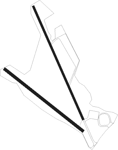
Runway info
Runway 18 / 36  | ||
| length | 519m (1703ft) | |
| bearing | 155° / 335° | |
| width | 9m (31ft) | |
| surface | gravel | |
| Runway 15 / 33 | ||
| length | 418m (1371ft) | |
| bearing | 125° / 305° | |
| width | 12m (40ft) | |
| surface | grass | |
Nearby beacons
| code | identifier | dist | bearing | frequency |
|---|---|---|---|---|
| SW | NEELY (NEWBURGH) NDB | 9.4 | 117° | 335 |
| HUO | HUGUENOT VOR/DME | 13 | 229° | 116.10 |
| SKU | STANWYCK (NEWBURGH) NDB | 16.3 | 97° | 261 |
| IGN | KINGSTON VOR/DME | 26.6 | 81° | 117.60 |
| SAX | SPARTA VORTAC | 31 | 195° | 115.70 |
| PWL | PAWLING (POUGHKEEPSIE) VOR/DME | 37.8 | 76° | 114.30 |
| STW | STILLWATER VOR/DME | 40.6 | 219° | 109.60 |
| CMK | CARMEL VOR/DME | 40.9 | 110° | 116.60 |
| MM | MOREE (MORRISTOWN) NDB | 41.8 | 174° | 392 |
| DNY | DE LANCEY VOR/DME | 43.9 | 317° | 112.10 |
| TEB | TETERBORO VOR/DME | 46.2 | 155° | 108.40 |
| TE | TORBY (TETERBORO) NDB | 47.8 | 161° | 214 |
| CAT | CHATHAM NDB | 50 | 182° | 254 |
| BWZ | BROADWAY (SCHOOLEY'S MT) VOR/DME | 50.3 | 208° | 114.20 |
| HNK | HANCOCK VOR/DME | 50.3 | 298° | 116.80 |
| PFH | PHILMONT (HUDSON) NDB | 50.8 | 45° | 272 |
| LGA | LA GUARDIA (NEW YORK) VOR/DME | 53.2 | 146° | 113.10 |
| SBJ | SOLBERG VOR/DME | 61.4 | 199° | 112.90 |
| CRI | CANARSIE VOR/DME | 62.1 | 152° | 112.30 |
| JFK | KENNEDY (NEW YORK) VOR/DME | 63.3 | 146° | 115.90 |
| FR | FRIKK (FARMINGDALE) NDB | 63.4 | 131° | 407 |
| RKA | ROCKDALE VOR/DME | 65.2 | 317° | 112.60 |
Disclaimer
The information on this website is not for real aviation. Use this data with the X-Plane flight simulator only! Data taken with kind consent from X-Plane 12 source code and data files. Content is subject to change without notice.