Big Sky - Nine Quarter Circle Ranch
Airport details
| Country | United States of America |
| State | Montana |
| Region | |
| Airspace | Salt Lake City Ctr |
| Municipality | Gallatin County |
| Elevation | 6974ft (2126m) |
| Timezone | GMT -7 |
| Coordinates | 45.07041, -111.30421 |
| Magnetic var | |
| Type | land |
| Available since | X-Plane v10.40 |
| ICAO code | 92U |
| IATA code | n/a |
| FAA code | n/a |
Communication
Nearby Points of Interest:
Crail Ranch Buildings
-Lonesomehurst Cabin
-OTO Homestead and Dude Ranch
-Eagle's Store
-West Yellowstone Oregon Shortline Terminus Historic District
-H.W. Child House
-Mammoth Hot Springs Historic District
-Fort Yellowstone
-North Entrance Road Historic District
-Union City, Montana
Runway info
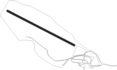
| Runway 10 / 28 | ||
| length | 1220m (4003ft) | |
| bearing | 114° / 294° | |
| width | 30m (100ft) | |
| surface | grass | |
Nearby beacons
| code | identifier | dist | bearing | frequency |
|---|---|---|---|---|
| EKS | ENNIS NDB | 18.9 | 300° | 286 |
| WYS | YELLOWSTONE DME | 24.8 | 156° | 114.85 |
| LO | TARGY (WEST YELLOWSTONE) NDB | 30 | 168° | 415 |
| BZN | BOZEMAN VOR/DME | 43.3 | 12° | 112.40 |
| BZ | MANNI (BOZEMAN) NDB | 48.1 | 1° | 266 |
| LVM | LIVINGSTON VOR/DME | 52.5 | 54° | 116.10 |
| HIA | WHITEHALL VOR/DME | 59.8 | 312° | 113.70 |
| DBS | DUBOIS VORTAC | 70.5 | 223° | 116.90 |
Disclaimer
The information on this website is not for real aviation. Use this data with the X-Plane flight simulator only! Data taken with kind consent from X-Plane 12 source code and data files. Content is subject to change without notice.