Oneida - Onida Muni
Airport details
| Country | United States of America |
| State | South Dakota |
| Region | K3 |
| Airspace | Minneapolis Ctr |
| Municipality | Sully County |
| Elevation | 1874ft (571m) |
| Timezone | GMT -6 |
| Coordinates | 44.70050, -100.10142 |
| Magnetic var | |
| Type | land |
| Available since | X-Plane v10.40 |
| ICAO code | 98D |
| IATA code | n/a |
| FAA code | n/a |
Communication
| Onida Muni CTAF | 122.900 |
Nearby Points of Interest:
Pierre Masonic Lodge
-Potter County Courthouse
-D.H. and Leah Curran House
-Brink-Wegner House
-I. W. Goodner House
-Peter Hansen House (Pierre, South Dakota)
-Farr House
-Karcher–Sahr House
-Dr. William and Elizabeth Blackburn House
-John E. and Ruth Hipple House
-Horner–Hyde House
-Hughes County Courthouse
-Crawford–Pettyjohn House
-South Dakota State Capitol
-Hilger Block
-Karcher Block
-Central Block (Pierre, South Dakota)
-Fort Pierre Congregational Church
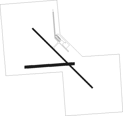
Runway info
Runway 13 / 31  | ||
| length | 1160m (3806ft) | |
| bearing | 129° / 309° | |
| width | 18m (60ft) | |
| surface | asphalt | |
| Runway 08 / 26 | ||
| length | 659m (2162ft) | |
| bearing | 90° / 270° | |
| width | 37m (120ft) | |
| surface | grass | |
Nearby beacons
| code | identifier | dist | bearing | frequency |
|---|---|---|---|---|
| PIR | PIERRE VORTAC | 18.5 | 191° | 112.50 |
Instrument approach procedures
| runway | airway (heading) | route (dist, bearing) |
|---|---|---|
| RW13 | WUKVA (130°) | WUKVA 4100ft |
| RNAV | WUKVA 4100ft ZENEV (6mi, 129°) 3500ft ZIMAP (3mi, 129°) 2680ft 98D (3mi, 130°) 1901ft (5835mi, 114°) 2140ft XUSDY (5829mi, 294°) 4200ft XUSDY (turn) | |
| RW31 | XUSDY (309°) | XUSDY 4200ft |
| RNAV | XUSDY 4200ft DUSRE (6mi, 310°) 3500ft VUJTE (2mi, 309°) 2800ft 98D (3mi, 309°) 1925ft (5835mi, 114°) 2220ft WUKVA (5842mi, 294°) 4100ft WUKVA (turn) |
Disclaimer
The information on this website is not for real aviation. Use this data with the X-Plane flight simulator only! Data taken with kind consent from X-Plane 12 source code and data files. Content is subject to change without notice.