Sebewaing
Airport details
| Country | United States of America |
| State | Michigan |
| Region | |
| Airspace | Cleveland Ctr |
| Municipality | Village of Sebewaing |
| Elevation | 583ft (178m) |
| Timezone | GMT -5 |
| Coordinates | 43.73244, -83.46429 |
| Magnetic var | |
| Type | land |
| Available since | X-Plane v10.40 |
| ICAO code | 98G |
| IATA code | n/a |
| FAA code | 98G |
Communication
| Sebewaing AWOS at BAX | 118.600 |
| Sebewaing CTAF/ UNICOM | 122.800 |
Nearby Points of Interest:
Indian Mission
-Tuscola County Courthouse
-First Presbyterian Church
-Trinity Episcopal Church
-Watrous General Store
-Richard C. Burtis House
-USS Edson
-Center Avenue Neighborhood Residential District
-Sanilac Petroglyphs Historic State Park
-Bay City Station
-Bay City Masonic Temple
-Bay City Downtown Historic District
-Albert E. Sleeper House
-Midland Street Commercial District
-Sage Library
-Trombley House
-Odd Fellows Valley Lodge No. 189 Building
-James Clements Municipal Airport
-Smith House
-Hotel Columbia
-McKinley School
-Randall House
-Second Arenac County Courthouse
-Michigan Central Railroad Standish Depot
-Flint and Pere Marquette Railroad East Saginaw Depot
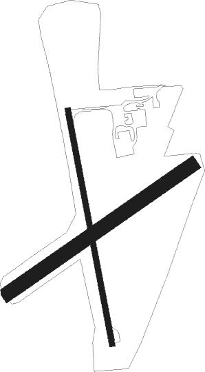
Runway info
Runway 18 / 36  | ||
| length | 665m (2182ft) | |
| bearing | 171° / 351° | |
| width | 15m (50ft) | |
| surface | asphalt | |
| displ threshold | 0m (0ft) / 77m (253ft) | |
| Runway 06 / 24 | ||
| length | 624m (2047ft) | |
| bearing | 67° / 247° | |
| width | 40m (130ft) | |
| surface | grass | |
Nearby beacons
| code | identifier | dist | bearing | frequency |
|---|---|---|---|---|
| MBS | SAGINAW VOR/DME | 29.2 | 252° | 112.90 |
| MB | OLSTE (SAGINAW) NDB | 35.1 | 249° | 257 |
| ASP | SABLE (OSCODA) DME | 43.1 | 6° | 116.10 |
| ECK | PECK TACAN | 43.3 | 123° | 114 |
| FNT | FLINT VORTAC | 47.6 | 200° | 116.90 |
| PH | PHURN (PORT HURON) NDB | 65.5 | 136° | 332 |
Disclaimer
The information on this website is not for real aviation. Use this data with the X-Plane flight simulator only! Data taken with kind consent from X-Plane 12 source code and data files. Content is subject to change without notice.