Chester - Chester Catawba Rgl
Airport details
| Country | United States of America |
| State | South Carolina |
| Region | K7 |
| Airspace | Atlanta Ctr |
| Municipality | Chester County |
| Elevation | 653ft (199m) |
| Timezone | GMT -5 |
| Coordinates | 34.78933, -81.19578 |
| Magnetic var | |
| Type | land |
| Available since | X-Plane v10.40 |
| ICAO code | 9A6 |
| IATA code | n/a |
| FAA code | DCM |
Communication
| Chester Catawba Rgl CTAF/UNICOM | 122.700 |
| Chester Catawba Rgl CHARLOTTE Approach/Departure | 120.050 |
Nearby Points of Interest:
People's Free Library of South Carolina
-Kumler Hall
-Chester City Hall and Opera House
-Withers Building
-Afro-American Insurance Company Building
-Marion Street Area Historic District
-Rock Hill Body Company
-People's National Bank Building
-United States Post Office and Courthouse
-Rock Hill Cotton Factory
-Reid Street-North Confederate Avenue Area Historic District
-White House
-Anderson House
-Hill Complex Historic District
-W.L. Hill Store
-Stokes-Mayfield House
-Highland Park Manufacturing Plant and Cotton Oil Complex
-Sharon Downtown Historic District
-Tillman Hall
-Charlotte Avenue-Aiken Avenue Historic District
-Hart House
-McCorkle-Fewell-Long House
-Wilson House
-York County Courthouse
-York Historic District
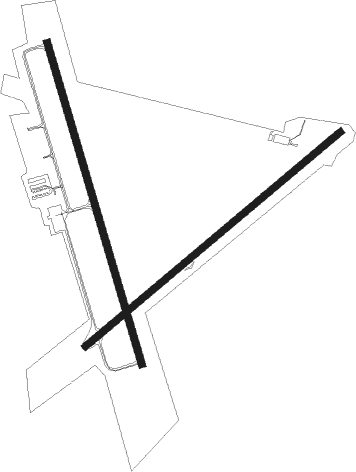
Runway info
Runway 17 / 35  | ||
| length | 1529m (5016ft) | |
| bearing | 166° / 346° | |
| width | 31m (103ft) | |
| surface | asphalt | |
| Runway 5 / 23 | ||
| length | 1524m (5000ft) | |
| bearing | 60° / 240° | |
| width | 30m (98ft) | |
| surface | asphalt | |
Nearby beacons
| code | identifier | dist | bearing | frequency |
|---|---|---|---|---|
| DCM | CHESTER NDB | 0.3 | 235° | 220 |
| UZ | RALLY (ROCK HILL) NDB | 8.2 | 49° | 227 |
| LKR | LANCASTER NDB | 17 | 101° | 400 |
| UOT | UNION COUNTY NDB | 22.9 | 257° | 326 |
| GHJ | STONIA (GASTONIA) NDB | 24.2 | 5° | 260 |
| CLT | CHARLOTTE VOR/DME | 26.9 | 31° | 115 |
| SLP | FIRST RIVER (SHELBY) NDB | 34.1 | 319° | 417 |
| EOE | ENOREE (NEWBERRY) NDB | 36 | 223° | 278 |
| SPA | SPARTANBURG VORTAC | 38.8 | 288° | 115.70 |
| CTF | CHESTERFIELD VOR/DME | 46.2 | 99° | 108.20 |
| CA | MURRY (COLUMBIA) NDB | 49.4 | 183° | 362 |
| GIW | CORONACA (GREENWOOD) NDB | 54.5 | 239° | 239 |
| MMT | MC ENTIRE (COLUMBIA) VORTAC | 55.5 | 156° | 113.20 |
| CAE | COLUMBIA VORTAC | 56.4 | 171° | 114.70 |
| GRD | GREENWOOD VORTAC | 57.3 | 241° | 115.50 |
| FIQ | FIDDLERS (MORGANTON) NDB | 60 | 333° | 391 |
| HK | TAWBA (HICKORY) NDB | 60.1 | 354° | 332 |
| SSC | SHAW (SUMTER) TACAN | 60.6 | 138° | 110.10 |
| SMS | SUMTER NDB | 63.3 | 134° | 252 |
| RU | ROVDY (SALISBURY) NDB | 66.4 | 37° | 275 |
Disclaimer
The information on this website is not for real aviation. Use this data with the X-Plane flight simulator only! Data taken with kind consent from X-Plane 12 source code and data files. Content is subject to change without notice.